Quintanavides elevation
Quintanavides (Castille and León, Provincia de Burgos), Spain elevation is 816 meters and Quintanavides elevation in feet is 2677 ft above sea level [src 1]. Quintanavides is a seat of a third-order administrative division (feature code) with elevation that is 213 meters (699 ft) bigger than average city elevation in Spain.
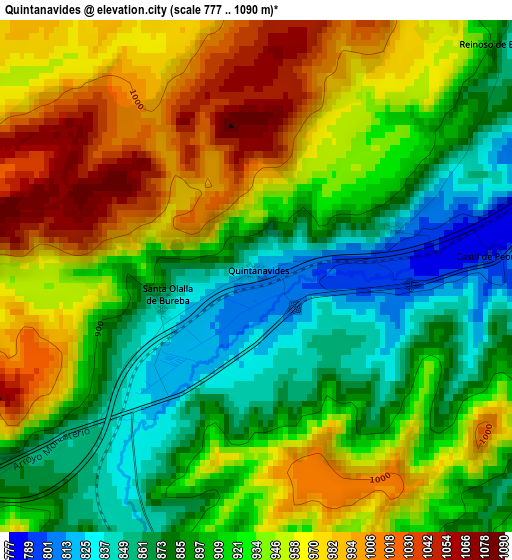
Below is the Elevation map of Quintanavides, which displays elevation range with different colors. Scale of the first map is from 777 to 1090 m (2549 to 3576 ft) with average elevation of 925.5 meters (=3036 ft) [note 1]
These maps also provides idea of topography and contour of this city, they are displayed at different zoom levels. More info about maps, scale and edge coordinates you can find below images.
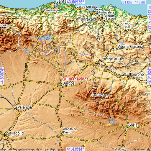
| \ | Map #1 | Topo.Map |
| Scale [m] | 777..1090 m | × |
| Scale [ft] | 2549..3576 ft | × |
| Average | 925.5 m = 3036 ft | × |
| Width | 7.21 km = 4.5 mi | 230.6 km = 143.3 mi |
| Height | 7.21 km = 4.5 mi | 230.6 km = 143.3 mi |
| ↑Max Latitude | 42.513241° | 43.50935° |
| Latitude at center | 42.48084° | 42.48084° |
| ↓Min Latitude | 42.448422° | 41.43514° |
| ← Min Longitude | -3.468435° | -4.83074° |
| Longitude center | -3.42449° | -3.42449° |
| →Max Longitude | -3.380545° | -2.01824° |
Nearby cities:
Cities around Quintanavides sort by population:
• Monasterio de Rodilla elevation 880 m
4.5 km,  235°
235°
• Santa María del Invierno 859 m
4.4 km,  194°
194°
• Villaescusa la Sombría 909 m
7.3 km,  176°
176°
• Prádanos de Bureba 757 m
6.8 km,  68°
68°
• Cerratón de Juarros 954 m
7.7 km,  147°
147°
• Alcocero de Mola 800 m
5.5 km,  99°
99°
• Arraya de Oca 929 m
7.7 km,  163°
163°
• Fresno de Rodilla 975 m
8.3 km,  216°
216°
• Santa Olalla de Bureba 853 m
1.4 km,  253°
253°
• Galbarros 938 m
5.3 km,  347°
347°
• Castil de Peones 790 m
3.3 km,  84°
84°
• Reinoso 893 m
4.5 km,  46°
46°
Multilingual:
 En español:
Quintanavides elevación 816 m.
 En France:
Quintanavides élévation 816 m.
 Auf Deutsch:
Quintanavides höhe über dem Meeresspiegel ist 816 m.

Sources and notes:
- [note 1] Map square and city borders are not equal. Map elevation data is calculated only from area inside that square.
- [src 1] Elevation data from geonames database provided with same terms of usage.
- [src 2] The elevation map of Quintanavides is generated using elevation data from NASA's 3 arcsec (90m) resolution SRTM data.
- [src 3] Base (background) map © OpenStreetMap contributors tiles are generated by Geofabrik and OpenTopoMap.
Copyright & License:
This Quintanavides Elevation Map is licensed under CC BY-SA. You may reuse any part from this page, if you give a proper credit by linking to this URL:
 More info on terms of use page.