Santibáñez de la Peña elevation
Santibáñez de la Peña (Castille and León, Provincia de Palencia), Spain elevation is 1114 meters and Santibáñez de la Peña elevation in feet is 3655 ft above sea level [src 1]. Santibáñez de la Peña is a seat of a third-order administrative division (feature code) with elevation that is 511 meters (1677 ft) bigger than average city elevation in Spain.
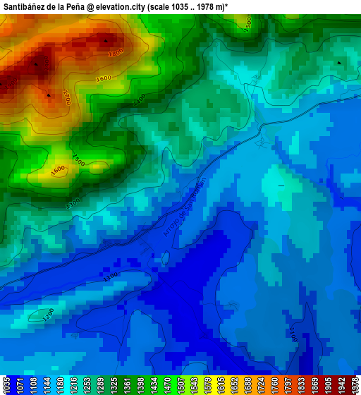
Below is the Elevation map of Santibáñez de la Peña, which displays elevation range with different colors. Scale of the first map is from 1035 to 1978 m (3396 to 6490 ft) with average elevation of 1252.4 meters (=4109 ft) [note 1]
These maps also provides idea of topography and contour of this city, they are displayed at different zoom levels. More info about maps, scale and edge coordinates you can find below images.
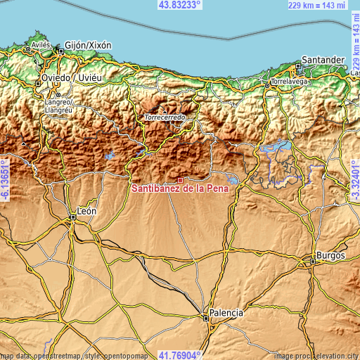
| \ | Map #1 | Topo.Map |
| Scale [m] | 1035..1978 m | × |
| Scale [ft] | 3396..6490 ft | × |
| Average | 1252.4 m = 4109 ft | × |
| Width | 7.17 km = 4.5 mi | 229.4 km = 142.5 mi |
| Height | 7.17 km = 4.5 mi | 229.4 km = 142.5 mi |
| ↑Max Latitude | 42.841521° | 43.83233° |
| Latitude at center | 42.80929° | 42.80929° |
| ↓Min Latitude | 42.777042° | 41.76904° |
| ← Min Longitude | -4.774205° | -6.13651° |
| Longitude center | -4.73026° | -4.73026° |
| →Max Longitude | -4.686315° | -3.32401° |
Nearby cities:
Cities around Santibáñez de la Peña sort by population:
• Guardo elevation 1094 m
9.9 km,  257°
257°
• Velilla del Río Carrión 1121 m
9.6 km,  281°
281°
• Ruesga 1044 m
17.5 km,  69°
69°
• Valderrueda 1034 m
17.7 km,  272°
272°
• Castrejón de la Peña 1122 m
10.7 km,  90°
90°
• Villalba de Guardo 1062 m
12.3 km,  218°
218°
• Congosto de Valdavia 976 m
13 km,  142°
142°
• Respenda de la Peña 1017 m
6.1 km, 143°
• Dehesa de Montejo 1095 m
18 km, 86°
• Mantinos 1067 m
11.1 km,  235°
235°
• Triollo 1300 m
13.4 km,  17°
17°
• Fresno del Río 1016 m
15.9 km,  206°
206°
Multilingual:
 En español:
Santibáñez de la Peña elevación 1114 m.
 En France:
Santibáñez de la Peña élévation 1114 m.
 Auf Deutsch:
Santibáñez de la Peña höhe über dem Meeresspiegel ist 1114 m.
 На русском:
Сантибаньес-де-ла-Пенья высота над уровнем моря 1114 м
Sources and notes:
- [note 1] Map square and city borders are not equal. Map elevation data is calculated only from area inside that square.
- [src 1] Elevation data from geonames database provided with same terms of usage.
- [src 2] The elevation map of Santibáñez de la Peña is generated using elevation data from NASA's 3 arcsec (90m) resolution SRTM data.
- [src 3] Base (background) map © OpenStreetMap contributors tiles are generated by Geofabrik and OpenTopoMap.
Copyright & License:
This Santibáñez de la Peña Elevation Map is licensed under CC BY-SA. You may reuse any part from this page, if you give a proper credit by linking to this URL:
 More info on terms of use page.