Santoña elevation
Santoña (Cantabria, Provincia de Cantabria), Spain elevation is 10 meters and Santoña elevation in feet is 33 ft above sea level [src 1]. Santoña is a seat of a third-order administrative division (feature code) with elevation that is 593 meters (1946 ft) smaller than average city elevation in Spain.
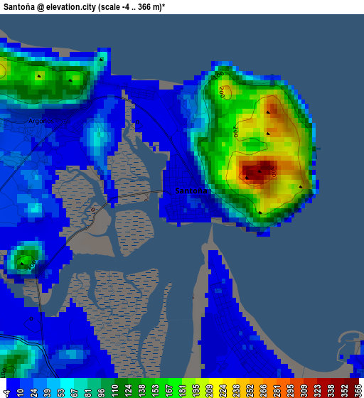
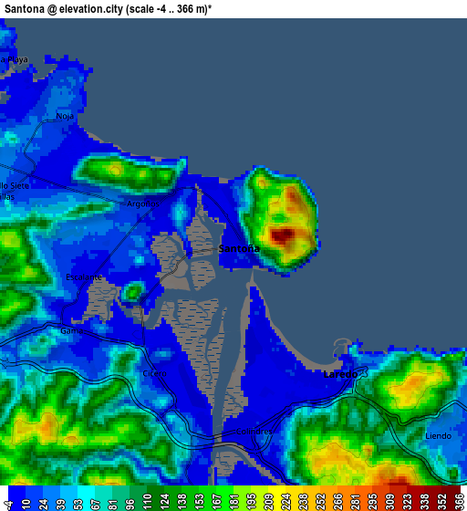
Below is the Elevation map of Santoña, which displays elevation range with different colors. Scale of the first map is from -4 to 366 m (-13 to 1201 ft) with average elevation of 64.9 meters (=213 ft) [note 1]
These maps also provides idea of topography and contour of this city, they are displayed at different zoom levels. More info about maps, scale and edge coordinates you can find below images.
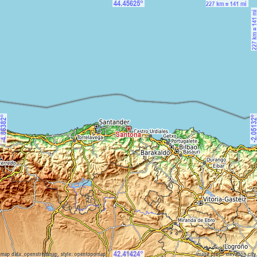
| \ | Map #1 | Map #2 | Topo.Map |
| Scale [m] | -4..366 m | -4..366 m | × |
| Scale [ft] | -13..1201 ft | -13..1201 ft | × |
| Average | 64.9 m = 213 ft | 72 m = 236 ft | × |
| Width | 7.1 km = 4.4 mi | 14.19 km = 8.8 mi | 227.1 km = 141.1 mi |
| Height | 7.1 km = 4.4 mi | 14.19 km = 8.8 mi | 227 km = 141.1 mi |
| ↑Max Latitude | 43.475758° | 43.507639° | 44.45625° |
| Latitude at center | 43.44386° | 43.44386° | 43.44386° |
| ↓Min Latitude | 43.411945° | 43.380013° | 42.41424° |
| ← Min Longitude | -3.501515° | -3.545461° | -4.86382° |
| Longitude center | -3.45757° | -3.45757° | -3.45757° |
| →Max Longitude | -3.413625° | -3.369679° | -2.05132° |
Nearby cities:
Cities around Santoña sort by population:
• Laredo elevation 6 m
5.1 km,  138°
138°
• Colindres 7 m
5.3 km,  176°
176°
• Ampuero 13 m
11.7 km,  163°
163°
• Bárcena de Cicero 20 m
4.9 km,  239°
239°
• Noja 23 m
7.3 km,  313°
313°
• Bareyo 76 m
11.8 km,  282°
282°
• Limpias 36 m
9.4 km, 160°
• San Miguel de Meruelo 11 m
10.8 km, 280°
• Argoños 7 m
3 km,  299°
299°
• Escalante 7 m
4.6 km,  260°
260°
• Arnuero 61 m
9.8 km,  292°
292°
• Liendo 26 m
8.5 km,  124°
124°
Multilingual:
 En español:
Santoña elevación 10 m.
 En France:
Santoña élévation 10 m.


Sources and notes:
- [note 1] Map square and city borders are not equal. Map elevation data is calculated only from area inside that square.
- [src 1] Elevation data from geonames database provided with same terms of usage.
- [src 2] The elevation map of Santoña is generated using elevation data from NASA's 3 arcsec (90m) resolution SRTM data.
- [src 3] Base (background) map © OpenStreetMap contributors tiles are generated by Geofabrik and OpenTopoMap.
Copyright & License:
This Santoña Elevation Map is licensed under CC BY-SA. You may reuse any part from this page, if you give a proper credit by linking to this URL:
 More info on terms of use page.