Sepúlveda elevation
Sepúlveda (Castille and León, Provincia de Segovia), Spain elevation is 1015 meters and Sepúlveda elevation in feet is 3330 ft above sea level [src 1]. Sepúlveda is a seat of a third-order administrative division (feature code) with elevation that is 412 meters (1352 ft) bigger than average city elevation in Spain.
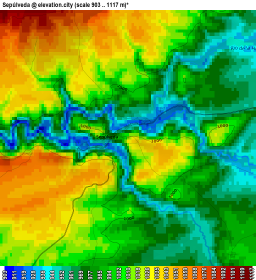
Below is the Elevation map of Sepúlveda, which displays elevation range with different colors. Scale of the first map is from 903 to 1117 m (2963 to 3665 ft) with average elevation of 999.4 meters (=3279 ft) [note 1]
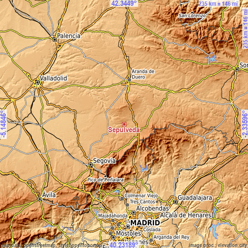
These maps also provides idea of topography and contour of this city, they are displayed at different zoom levels. More info about maps, scale and edge coordinates you can find below images.
| \ | Map #1 | Topo.Map |
| Scale [m] | 903..1117 m | × |
| Scale [ft] | 2963..3665 ft | × |
| Average | 999.4 m = 3279 ft | × |
| Width | 7.34 km = 4.6 mi | 234.9 km = 146 mi |
| Height | 7.34 km = 4.6 mi | 234.9 km = 146 mi |
| ↑Max Latitude | 41.329958° | 42.3449° |
| Latitude at center | 41.29695° | 41.29695° |
| ↓Min Latitude | 41.263926° | 40.23189° |
| ← Min Longitude | -3.786155° | -5.14846° |
| Longitude center | -3.74221° | -3.74221° |
| →Max Longitude | -3.698265° | -2.33596° |
Nearby cities:
Cities around Sepúlveda sort by population:
• Boceguillas elevation 963 m
9.7 km,  63°
63°
• San Pedro de Gaíllos 990 m
9.6 km,  215°
215°
• Barbolla 942 m
6.6 km, 60°
• Duruelo 1011 m
10.3 km,  130°
130°
• Navares de Enmedio 1041 m
9.5 km,  9°
9°
• Urueñas 1052 m
7.1 km,  338°
338°
• Aldeonte 967 m
8 km,  41°
41°
• Navares de Ayuso 1017 m
9.1 km,  18°
18°
• Santa Marta del Cerro 1028 m
9.9 km,  151°
151°
• Castroserna de Abajo 985 m
9.9 km,  175°
175°
• Sotillo 986 m
9.8 km,  116°
116°
• Aldealcorvo 958 m
7.1 km, 215°
Multilingual:
 En español:
Sepúlveda elevación 1015 m.
 En France:
Sepúlveda élévation 1015 m.
 Auf Deutsch:
Sepúlveda höhe über dem Meeresspiegel ist 1015 m.

Sources and notes:
- [note 1] Map square and city borders are not equal. Map elevation data is calculated only from area inside that square.
- [src 1] Elevation data from geonames database provided with same terms of usage.
- [src 2] The elevation map of Sepúlveda is generated using elevation data from NASA's 3 arcsec (90m) resolution SRTM data.
- [src 3] Base (background) map © OpenStreetMap contributors tiles are generated by Geofabrik and OpenTopoMap.
Copyright & License:
This Sepúlveda Elevation Map is licensed under CC BY-SA. You may reuse any part from this page, if you give a proper credit by linking to this URL:
 More info on terms of use page.