Tábara elevation
Tábara (Castille and León, Provincia de Zamora), Spain elevation is 754 meters and Tábara elevation in feet is 2474 ft above sea level [src 1]. Tábara is a seat of a third-order administrative division (feature code) with elevation that is 151 meters (495 ft) bigger than average city elevation in Spain.
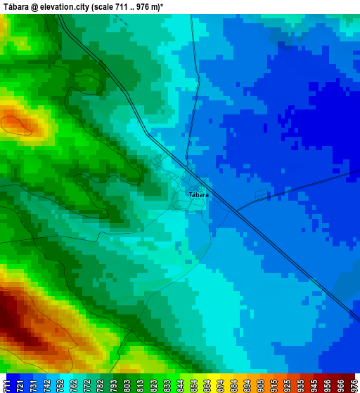
Below is the Elevation map of Tábara, which displays elevation range with different colors. Scale of the first map is from 711 to 976 m (2333 to 3202 ft) with average elevation of 774.1 meters (=2540 ft) [note 1]
These maps also provides idea of topography and contour of this city, they are displayed at different zoom levels. More info about maps, scale and edge coordinates you can find below images.
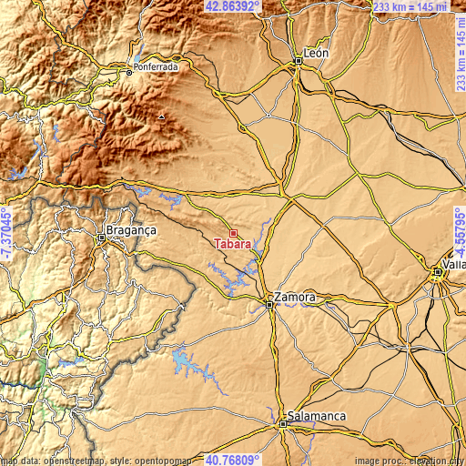
| \ | Map #1 | Topo.Map |
| Scale [m] | 711..976 m | × |
| Scale [ft] | 2333..3202 ft | × |
| Average | 774.1 m = 2540 ft | × |
| Width | 7.28 km = 4.5 mi | 233 km = 144.8 mi |
| Height | 7.28 km = 4.5 mi | 233 km = 144.8 mi |
| ↑Max Latitude | 41.857319° | 42.86392° |
| Latitude at center | 41.82458° | 41.82458° |
| ↓Min Latitude | 41.791824° | 40.76809° |
| ← Min Longitude | -6.008145° | -7.37045° |
| Longitude center | -5.9642° | -5.9642° |
| →Max Longitude | -5.920255° | -4.55795° |
Nearby cities:
Cities around Tábara sort by population:
• Ferreras de Abajo elevation 823 m
12.4 km,  310°
310°
• Ferreruela 828 m
11 km,  234°
234°
• Faramontanos de Tábara 713 m
6.3 km,  79°
79°
• Moreruela de Tábara 696 m
8.5 km,  111°
111°
• Olmillos de Castro 767 m
10.3 km,  181°
181°
• Pueblica de Valverde 730 m
11.7 km,  27°
27°
• Morales de Valverde 732 m
13.8 km, 25°
• Friera de Valverde 721 m
14.1 km,  46°
46°
• Perilla de Castro 726 m
13.2 km,  146°
146°
• Pozuelo de Tábara 702 m
7.3 km,  127°
127°
• Villanueva de las Peras 744 m
12.3 km,  354°
354°
• Santa María de Valverde 734 m
12.5 km,  10°
10°
Multilingual:
 En español:
Tábara elevación 754 m.
 En France:
Tábara élévation 754 m.


Sources and notes:
- [note 1] Map square and city borders are not equal. Map elevation data is calculated only from area inside that square.
- [src 1] Elevation data from geonames database provided with same terms of usage.
- [src 2] The elevation map of Tábara is generated using elevation data from NASA's 3 arcsec (90m) resolution SRTM data.
- [src 3] Base (background) map © OpenStreetMap contributors tiles are generated by Geofabrik and OpenTopoMap.
Copyright & License:
This Tábara Elevation Map is licensed under CC BY-SA. You may reuse any part from this page, if you give a proper credit by linking to this URL:
 More info on terms of use page.