Tagamanent elevation
Tagamanent (Catalonia, Província de Barcelona), Spain elevation is 345 meters and Tagamanent elevation in feet is 1132 ft above sea level [src 1]. Tagamanent is a seat of a third-order administrative division (feature code) with elevation that is 258 meters (846 ft) smaller than average city elevation in Spain.
Below is the Elevation map of Tagamanent, which displays elevation range with different colors. Scale of the first map is from 268 to 1122 m (879 to 3681 ft) with average elevation of 622.2 meters (=2041 ft) [note 1]
These maps also provides idea of topography and contour of this city, they are displayed at different zoom levels. More info about maps, scale and edge coordinates you can find below images.
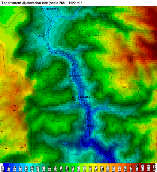
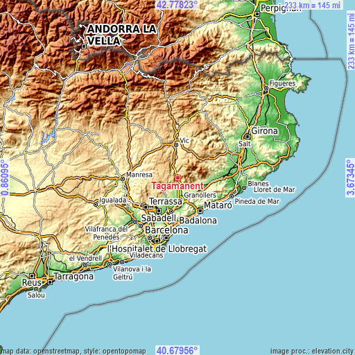
| \ | Map #1 | Topo.Map |
| Scale [m] | 268..1122 m | × |
| Scale [ft] | 879..3681 ft | × |
| Average | 622.2 m = 2041 ft | × |
| Width | 7.29 km = 4.5 mi | 233.4 km = 145 mi |
| Height | 7.29 km = 4.5 mi | 233.3 km = 145 mi |
| ↑Max Latitude | 41.770254° | 42.77823° |
| Latitude at center | 41.73747° | 41.73747° |
| ↓Min Latitude | 41.70467° | 40.67956° |
| ← Min Longitude | 2.223255° | 0.86095° |
| Longitude center | 2.2672° | 2.2672° |
| →Max Longitude | 2.311145° | 3.67345° |
Nearby cities:
Cities around Tagamanent sort by population:
• la Garriga elevation 241 m
6.2 km,  167°
167°
• L'Ametlla del Vallès 266 m
7.9 km,  180°
180°
• Bigues i Riells 377 m
6.6 km,  205°
205°
• Centelles 532 m
7.8 km,  329°
329°
• Santa Eulàlia de Ronçana 165 m
10.1 km,  196°
196°
• Cànoves i Samalús 357 m
9.1 km,  131°
131°
• Aiguafreda 409 m
3.7 km,  337°
337°
• Figaró 326 m
1.9 km, 165°
• Sant Martí de Centelles 709 m
6 km,  302°
302°
• Castellcir 720 m
9.2 km,  286°
286°
• Sant Quirze Safaja 672 m
9.7 km,  267°
267°
• Sant Feliu de Codines 597 m
9.3 km,  243°
243°
Multilingual:
 En español:
Tagamanent elevación 345 m.
 En France:
Tagamanent élévation 345 m.
 Auf Deutsch:
Tagamanent höhe über dem Meeresspiegel ist 345 m.

Sources and notes:
- [note 1] Map square and city borders are not equal. Map elevation data is calculated only from area inside that square.
- [src 1] Elevation data from geonames database provided with same terms of usage.
- [src 2] The elevation map of Tagamanent is generated using elevation data from NASA's 3 arcsec (90m) resolution SRTM data.
- [src 3] Base (background) map © OpenStreetMap contributors tiles are generated by Geofabrik and OpenTopoMap.
Copyright & License:
This Tagamanent Elevation Map is licensed under CC BY-SA. You may reuse any part from this page, if you give a proper credit by linking to this URL:
 More info on terms of use page.