Talamanca elevation
Talamanca (Catalonia, Província de Barcelona), Spain elevation is 560 meters and Talamanca elevation in feet is 1837 ft above sea level [src 1]. Talamanca is a seat of a third-order administrative division (feature code) with elevation that is 43 meters (141 ft) smaller than average city elevation in Spain.
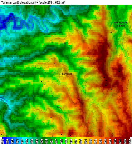
Below is the Elevation map of Talamanca, which displays elevation range with different colors. Scale of the first map is from 274 to 682 m (899 to 2238 ft) with average elevation of 488.4 meters (=1602 ft) [note 1]
These maps also provides idea of topography and contour of this city, they are displayed at different zoom levels. More info about maps, scale and edge coordinates you can find below images.
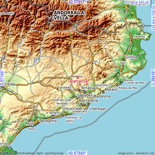
| \ | Map #1 | Topo.Map |
| Scale [m] | 274..682 m | × |
| Scale [ft] | 899..2238 ft | × |
| Average | 488.4 m = 1602 ft | × |
| Width | 7.29 km = 4.5 mi | 233.4 km = 145 mi |
| Height | 7.29 km = 4.5 mi | 233.3 km = 145 mi |
| ↑Max Latitude | 41.770184° | 42.77817° |
| Latitude at center | 41.7374° | 41.7374° |
| ↓Min Latitude | 41.704599° | 40.67949° |
| ← Min Longitude | 1.933965° | 0.57166° |
| Longitude center | 1.97791° | 1.97791° |
| →Max Longitude | 2.021855° | 3.38416° |
Nearby cities:
Cities around Talamanca sort by population:
• Manresa elevation 241 m
12.8 km,  265°
265°
• Sant Vicenç de Castellet 198 m
12.1 km,  229°
229°
• Sallent 290 m
12 km,  325°
325°
• Navarcles 256 m
6.4 km,  284°
284°
• Moià 709 m
12.9 km,  50°
50°
• Artés 317 m
7 km,  343°
343°
• Gallifa 482 m
12.3 km,  113°
113°
• Mura 461 m
4.2 km,  182°
182°
• Granera 774 m
6.8 km,  99°
99°
• Santpedor 315 m
12 km,  295°
295°
• Castellterçol 727 m
11.6 km,  83°
83°
• Sant Fruitós de Bages 250 m
9.3 km, 278°
Multilingual:
 En español:
Talamanca elevación 560 m.
 En France:
Talamanca élévation 560 m.
 Auf Deutsch:
Talamanca höhe über dem Meeresspiegel ist 560 m.

Sources and notes:
- [note 1] Map square and city borders are not equal. Map elevation data is calculated only from area inside that square.
- [src 1] Elevation data from geonames database provided with same terms of usage.
- [src 2] The elevation map of Talamanca is generated using elevation data from NASA's 3 arcsec (90m) resolution SRTM data.
- [src 3] Base (background) map © OpenStreetMap contributors tiles are generated by Geofabrik and OpenTopoMap.
Copyright & License:
This Talamanca Elevation Map is licensed under CC BY-SA. You may reuse any part from this page, if you give a proper credit by linking to this URL:
 More info on terms of use page.