Tamames elevation
Tamames (Castille and León, Provincia de Salamanca), Spain elevation is 902 meters and Tamames elevation in feet is 2959 ft above sea level [src 1]. Tamames is a seat of a third-order administrative division (feature code) with elevation that is 299 meters (981 ft) bigger than average city elevation in Spain.
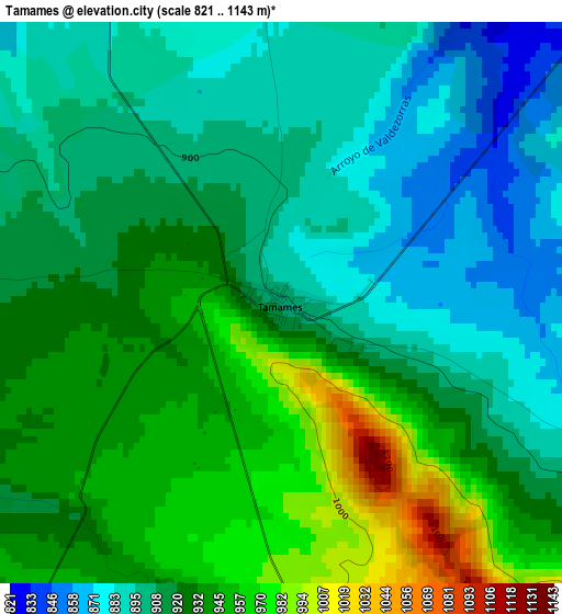
Below is the Elevation map of Tamames, which displays elevation range with different colors. Scale of the first map is from 821 to 1143 m (2694 to 3750 ft) with average elevation of 919.6 meters (=3017 ft) [note 1]
These maps also provides idea of topography and contour of this city, they are displayed at different zoom levels. More info about maps, scale and edge coordinates you can find below images.
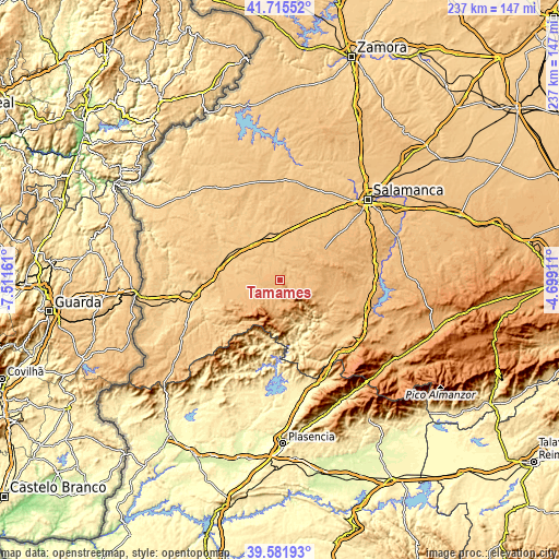
| \ | Map #1 | Topo.Map |
| Scale [m] | 821..1143 m | × |
| Scale [ft] | 2694..3750 ft | × |
| Average | 919.6 m = 3017 ft | × |
| Width | 7.41 km = 4.6 mi | 237.2 km = 147.4 mi |
| Height | 7.41 km = 4.6 mi | 237.2 km = 147.4 mi |
| ↑Max Latitude | 40.690579° | 41.71552° |
| Latitude at center | 40.65725° | 40.65725° |
| ↓Min Latitude | 40.623904° | 39.58193° |
| ← Min Longitude | -6.149305° | -7.51161° |
| Longitude center | -6.10536° | -6.10536° |
| →Max Longitude | -6.061415° | -4.69911° |
Nearby cities:
Cities around Tamames sort by population:
• Cabrillas elevation 799 m
11.1 km,  326°
326°
• Escurial de la Sierra 960 m
13.4 km,  109°
109°
• Navarredonda de la Rinconada 1026 m
9.7 km,  125°
125°
• Abusejo 842 m
6.5 km, 332°
• Aldehuela de Yeltes 836 m
11.7 km,  272°
272°
• Puebla de Yeltes 878 m
7.3 km,  241°
241°
• Aldeanueva de la Sierra 981 m
4.6 km,  174°
174°
• Tejeda y Segoyuela 926 m
7.5 km, 112°
• Berrocal de Huebra 897 m
11.2 km,  52°
52°
• Cereceda de la Sierra 982 m
10.2 km, 173°
• Sanchón de la Sagrada 876 m
11.7 km,  35°
35°
• Cilleros de la Bastida 1068 m
9.8 km,  157°
157°
Multilingual:
 En español:
Tamames elevación 902 m.
 En France:
Tamames élévation 902 m.


Sources and notes:
- [note 1] Map square and city borders are not equal. Map elevation data is calculated only from area inside that square.
- [src 1] Elevation data from geonames database provided with same terms of usage.
- [src 2] The elevation map of Tamames is generated using elevation data from NASA's 3 arcsec (90m) resolution SRTM data.
- [src 3] Base (background) map © OpenStreetMap contributors tiles are generated by Geofabrik and OpenTopoMap.
Copyright & License:
This Tamames Elevation Map is licensed under CC BY-SA. You may reuse any part from this page, if you give a proper credit by linking to this URL:
 More info on terms of use page.