Tenebrón elevation
Tenebrón (Castille and León, Provincia de Salamanca), Spain elevation is 826 meters and Tenebrón elevation in feet is 2710 ft above sea level [src 1]. Tenebrón is a seat of a third-order administrative division (feature code) with elevation that is 223 meters (732 ft) bigger than average city elevation in Spain.
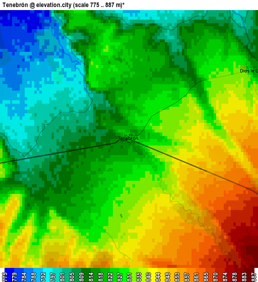
Below is the Elevation map of Tenebrón, which displays elevation range with different colors. Scale of the first map is from 775 to 887 m (2543 to 2910 ft) with average elevation of 825.5 meters (=2708 ft) [note 1]
These maps also provides idea of topography and contour of this city, they are displayed at different zoom levels. More info about maps, scale and edge coordinates you can find below images.
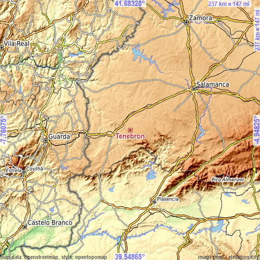
| \ | Map #1 | Topo.Map |
| Scale [m] | 775..887 m | × |
| Scale [ft] | 2543..2910 ft | × |
| Average | 825.5 m = 2708 ft | × |
| Width | 7.42 km = 4.6 mi | 237.3 km = 147.5 mi |
| Height | 7.42 km = 4.6 mi | 237.3 km = 147.5 mi |
| ↑Max Latitude | 40.657836° | 41.68328° |
| Latitude at center | 40.62449° | 40.62449° |
| ↓Min Latitude | 40.591127° | 39.54865° |
| ← Min Longitude | -6.398445° | -7.76075° |
| Longitude center | -6.3545° | -6.3545° |
| →Max Longitude | -6.310555° | -4.94825° |
Nearby cities:
Cities around Tenebrón sort by population:
• Ciudad Rodrigo elevation 650 m
15.3 km,  259°
259°
• Martín de Yeltes 764 m
17.7 km,  17°
17°
• Serradilla del Arroyo 855 m
11.5 km,  182°
182°
• Morasverdes 898 m
7.2 km,  111°
111°
• Alba de Yeltes 790 m
6.2 km,  31°
31°
• Aldehuela de Yeltes 836 m
10.3 km,  65°
65°
• Puebla de Yeltes 878 m
14.6 km,  89°
89°
• Serradilla del Llano 877 m
13.8 km, 180°
• Monsagro 956 m
15.2 km,  152°
152°
• Dios le Guarde 829 m
3.9 km,  58°
58°
• Zamarra 781 m
14.4 km,  215°
215°
• Castraz 763 m
9.1 km,  10°
10°
Multilingual:
 En español:
Tenebrón elevación 826 m.
 En France:
Tenebrón élévation 826 m.
 Auf Deutsch:
Tenebrón höhe über dem Meeresspiegel ist 826 m.

Sources and notes:
- [note 1] Map square and city borders are not equal. Map elevation data is calculated only from area inside that square.
- [src 1] Elevation data from geonames database provided with same terms of usage.
- [src 2] The elevation map of Tenebrón is generated using elevation data from NASA's 3 arcsec (90m) resolution SRTM data.
- [src 3] Base (background) map © OpenStreetMap contributors tiles are generated by Geofabrik and OpenTopoMap.
Copyright & License:
This Tenebrón Elevation Map is licensed under CC BY-SA. You may reuse any part from this page, if you give a proper credit by linking to this URL:
 More info on terms of use page.