Tolosa elevation
Tolosa (Basque Country, Gipuzkoa), Spain elevation is 80 meters and Tolosa elevation in feet is 262 ft above sea level [src 1]. Tolosa is a seat of a third-order administrative division (feature code) with elevation that is 523 meters (1716 ft) smaller than average city elevation in Spain.
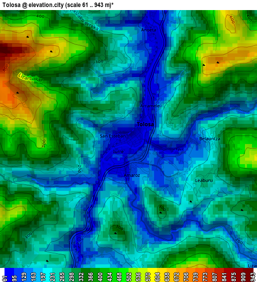
Below is the Elevation map of Tolosa, which displays elevation range with different colors. Scale of the first map is from 61 to 943 m (200 to 3094 ft) with average elevation of 297.4 meters (=976 ft) [note 1]
These maps also provides idea of topography and contour of this city, they are displayed at different zoom levels. More info about maps, scale and edge coordinates you can find below images.
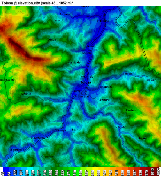
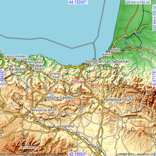
| \ | Map #1 | Map #2 | Topo.Map |
| Scale [m] | 61..943 m | 45..1052 m | × |
| Scale [ft] | 200..3094 ft | 148..3451 ft | × |
| Average | 297.4 m = 976 ft | 376.1 m = 1234 ft | × |
| Width | 7.13 km = 4.4 mi | 14.26 km = 8.9 mi | 228.2 km = 141.8 mi |
| Height | 7.13 km = 4.4 mi | 14.26 km = 8.9 mi | 228.2 km = 141.8 mi |
| ↑Max Latitude | 43.166901° | 43.198944° | 44.15243° |
| Latitude at center | 43.13484° | 43.13484° | 43.13484° |
| ↓Min Latitude | 43.102763° | 43.070668° | 42.10003° |
| ← Min Longitude | -2.121955° | -2.165901° | -3.48426° |
| Longitude center | -2.07801° | -2.07801° | -2.07801° |
| →Max Longitude | -2.034065° | -1.990119° | -0.67176° |
Nearby cities:
Cities around Tolosa sort by population:
• Irura elevation 87 m
3.6 km,  13°
13°
• Berrobi 155 m
4.4 km,  74°
74°
• Leaburu 253 m
2.4 km,  126°
126°
• Hernialde 290 m
2.3 km,  345°
345°
• Albiztur 280 m
4.8 km,  262°
262°
• Gaztelu 455 m
4.8 km,  115°
115°
• Lizartza 140 m
5 km,  135°
135°
• Alkiza 340 m
4.9 km,  328°
328°
• Alegia 94 m
4.1 km,  201°
201°
• Anoeta 73 m
3.1 km, 10°
• Belauntza 202 m
2.1 km,  86°
86°
• Ibarra 83 m
1.1 km,  110°
110°
Multilingual:
 En español:
Tolosa elevación 80 m.
 En France:
Tolosa élévation 80 m.


Sources and notes:
- [note 1] Map square and city borders are not equal. Map elevation data is calculated only from area inside that square.
- [src 1] Elevation data from geonames database provided with same terms of usage.
- [src 2] The elevation map of Tolosa is generated using elevation data from NASA's 3 arcsec (90m) resolution SRTM data.
- [src 3] Base (background) map © OpenStreetMap contributors tiles are generated by Geofabrik and OpenTopoMap.
Copyright & License:
This Tolosa Elevation Map is licensed under CC BY-SA. You may reuse any part from this page, if you give a proper credit by linking to this URL:
 More info on terms of use page.