Tona elevation
Tona (Catalonia, Província de Barcelona), Spain elevation is 603 meters and Tona elevation in feet is 1978 ft above sea level [src 1]. Tona is a seat of a third-order administrative division (feature code) with elevation that is 0 meters (0 ft) bigger than average city elevation in Spain.
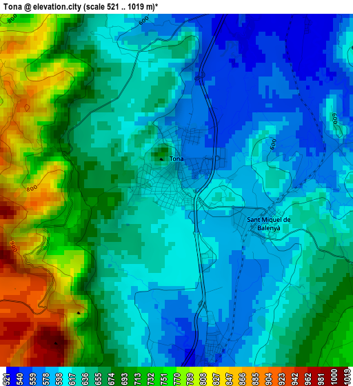
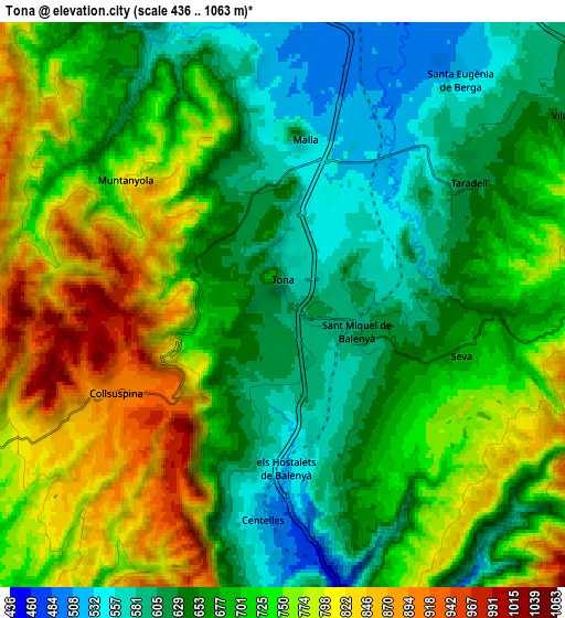
Below is the Elevation map of Tona, which displays elevation range with different colors. Scale of the first map is from 521 to 1019 m (1709 to 3343 ft) with average elevation of 656 meters (=2152 ft) [note 1]
These maps also provides idea of topography and contour of this city, they are displayed at different zoom levels. More info about maps, scale and edge coordinates you can find below images.
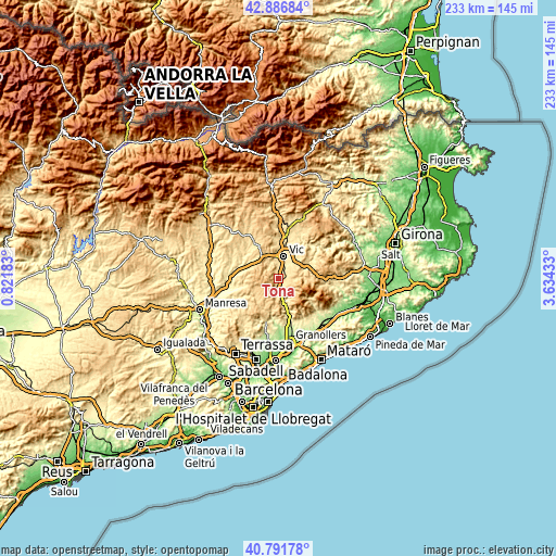
| \ | Map #1 | Map #2 | Topo.Map |
| Scale [m] | 521..1019 m | 436..1063 m | × |
| Scale [ft] | 1709..3343 ft | 1430..3488 ft | × |
| Average | 656 m = 2152 ft | 700.9 m = 2300 ft | × |
| Width | 7.28 km = 4.5 mi | 14.56 km = 9 mi | 232.9 km = 144.7 mi |
| Height | 7.28 km = 4.5 mi | 14.56 km = 9 mi | 232.9 km = 144.7 mi |
| ↑Max Latitude | 41.880617° | 41.913328° | 42.88684° |
| Latitude at center | 41.84789° | 41.84789° | 41.84789° |
| ↓Min Latitude | 41.815146° | 41.782385° | 40.79178° |
| ← Min Longitude | 2.184135° | 2.140189° | 0.82183° |
| Longitude center | 2.22808° | 2.22808° | 2.22808° |
| →Max Longitude | 2.272025° | 2.315971° | 3.63433° |
Nearby cities:
Cities around Tona sort by population:
• Vic elevation 507 m
9.4 km,  13°
13°
• Centelles 532 m
5.7 km,  187°
187°
• Taradell 629 m
5.7 km,  58°
58°
• Moià 709 m
11.5 km,  249°
249°
• Seva 668 m
4.4 km,  103°
103°
• Aiguafreda 409 m
9.1 km,  168°
168°
• Santa Eugènia de Berga 541 m
7.4 km,  38°
38°
• Sant Martí de Centelles 709 m
9.3 km, 191°
• Castellcir 720 m
11.2 km,  209°
209°
• Collsuspina 903 m
5 km,  240°
240°
• Sant Julià de Vilatorta 600 m
11.5 km, 44°
• Muntanyola 745 m
5.4 km,  316°
316°
Multilingual:
 En español:
Tona elevación 603 m.
 En France:
Tona élévation 603 m.


Sources and notes:
- [note 1] Map square and city borders are not equal. Map elevation data is calculated only from area inside that square.
- [src 1] Elevation data from geonames database provided with same terms of usage.
- [src 2] The elevation map of Tona is generated using elevation data from NASA's 3 arcsec (90m) resolution SRTM data.
- [src 3] Base (background) map © OpenStreetMap contributors tiles are generated by Geofabrik and OpenTopoMap.
Copyright & License:
This Tona Elevation Map is licensed under CC BY-SA. You may reuse any part from this page, if you give a proper credit by linking to this URL:
 More info on terms of use page.