Tordómar elevation
Tordómar (Castille and León, Provincia de Burgos), Spain elevation is 814 meters and Tordómar elevation in feet is 2671 ft above sea level [src 1]. Tordómar is a seat of a third-order administrative division (feature code) with elevation that is 211 meters (692 ft) bigger than average city elevation in Spain.
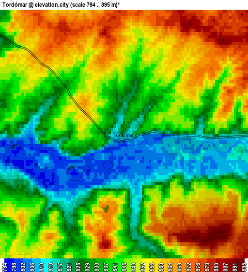
Below is the Elevation map of Tordómar, which displays elevation range with different colors. Scale of the first map is from 794 to 895 m (2605 to 2936 ft) with average elevation of 843.3 meters (=2767 ft) [note 1]
These maps also provides idea of topography and contour of this city, they are displayed at different zoom levels. More info about maps, scale and edge coordinates you can find below images.
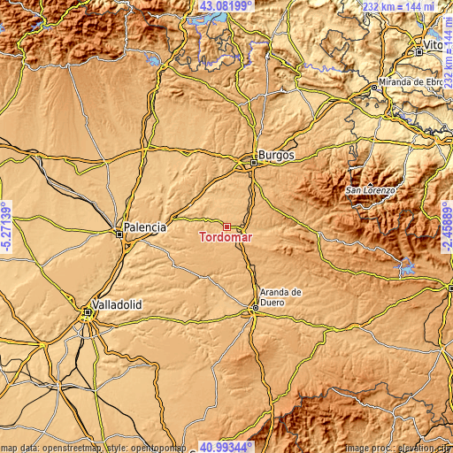
| \ | Map #1 | Topo.Map |
| Scale [m] | 794..895 m | × |
| Scale [ft] | 2605..2936 ft | × |
| Average | 843.3 m = 2767 ft | × |
| Width | 7.26 km = 4.5 mi | 232.2 km = 144.3 mi |
| Height | 7.26 km = 4.5 mi | 232.2 km = 144.3 mi |
| ↑Max Latitude | 42.078926° | 43.08199° |
| Latitude at center | 42.0463° | 42.0463° |
| ↓Min Latitude | 42.013658° | 40.99344° |
| ← Min Longitude | -3.909085° | -5.27139° |
| Longitude center | -3.86514° | -3.86514° |
| →Max Longitude | -3.821195° | -2.45889° |
Nearby cities:
Cities around Tordómar sort by population:
• Lerma elevation 836 m
9 km,  104°
104°
• Villalmanzo 856 m
10.2 km,  88°
88°
• Villahoz 832 m
5.1 km,  309°
309°
• Royuela de Río Franco 831 m
8.9 km,  236°
236°
• Villamayor de los Montes 888 m
10.5 km,  51°
51°
• Espinosa de Cerrato 886 m
11.5 km,  219°
219°
• Mahamud 830 m
10.3 km,  322°
322°
• Quintanilla de la Mata 877 m
10.3 km,  128°
128°
• Avellanosa de Muñó 872 m
7.7 km,  154°
154°
• Zael 842 m
7.4 km,  25°
25°
• Santa Cecilia 841 m
5.1 km,  82°
82°
• Iglesiarrubia 889 m
8.2 km,  169°
169°
Multilingual:
 En español:
Tordómar elevación 814 m.
 En France:
Tordómar élévation 814 m.
 Auf Deutsch:
Tordómar höhe über dem Meeresspiegel ist 814 m.

Sources and notes:
- [note 1] Map square and city borders are not equal. Map elevation data is calculated only from area inside that square.
- [src 1] Elevation data from geonames database provided with same terms of usage.
- [src 2] The elevation map of Tordómar is generated using elevation data from NASA's 3 arcsec (90m) resolution SRTM data.
- [src 3] Base (background) map © OpenStreetMap contributors tiles are generated by Geofabrik and OpenTopoMap.
Copyright & License:
This Tordómar Elevation Map is licensed under CC BY-SA. You may reuse any part from this page, if you give a proper credit by linking to this URL:
 More info on terms of use page.