Torelló elevation
Torelló (Catalonia, Província de Barcelona), Spain elevation is 517 meters and Torelló elevation in feet is 1696 ft above sea level [src 1]. Torelló is a populated place (feature code) with elevation that is 86 meters (282 ft) smaller than average city elevation in Spain.
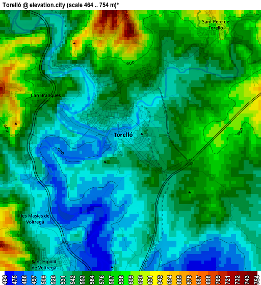
Below is the Elevation map of Torelló, which displays elevation range with different colors. Scale of the first map is from 464 to 754 m (1522 to 2474 ft) with average elevation of 552.3 meters (=1812 ft) [note 1]
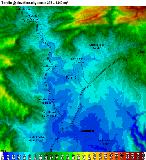
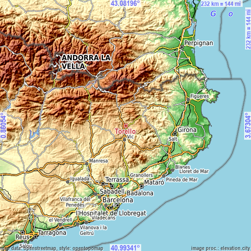
These maps also provides idea of topography and contour of this city, they are displayed at different zoom levels. More info about maps, scale and edge coordinates you can find below images.
| \ | Map #1 | Map #2 | Topo.Map |
| Scale [m] | 464..754 m | 398..1340 m | × |
| Scale [ft] | 1522..2474 ft | 1306..4396 ft | × |
| Average | 552.3 m = 1812 ft | 630.8 m = 2070 ft | × |
| Width | 7.26 km = 4.5 mi | 14.51 km = 9 mi | 232.2 km = 144.3 mi |
| Height | 7.26 km = 4.5 mi | 14.51 km = 9 mi | 232.2 km = 144.3 mi |
| ↑Max Latitude | 42.078896° | 42.111504° | 43.08196° |
| Latitude at center | 42.04627° | 42.04627° | 42.04627° |
| ↓Min Latitude | 42.013628° | 41.980969° | 40.99341° |
| ← Min Longitude | 2.222845° | 2.178899° | 0.86054° |
| Longitude center | 2.26679° | 2.26679° | 2.26679° |
| →Max Longitude | 2.310735° | 2.354681° | 3.67304° |
Nearby cities:
Cities around Torelló sort by population:
• Vic elevation 507 m
13 km,  184°
184°
• Manlleu 461 m
5.1 km,  163°
163°
• Vilaseca 536 m
2 km,  331°
331°
• Gurb 512 m
10.6 km,  194°
194°
• Santa Maria de Corcó 676 m
8.4 km,  99°
99°
• Santa Cecília de Voltregà 525 m
5.8 km,  208°
208°
• Vidrà 982 m
9.2 km,  22°
22°
• Tavertet 865 m
13.7 km,  114°
114°
• Sora 714 m
11.4 km,  310°
310°
• Sant Boi de Lluçanès 754 m
9.7 km,  272°
272°
• Montesquiu 681 m
8.9 km, 332°
• Orís 712 m
4.1 km,  291°
291°
Multilingual:
 En español:
Torelló elevación 517 m.
 En France:
Torelló élévation 517 m.


Sources and notes:
- [note 1] Map square and city borders are not equal. Map elevation data is calculated only from area inside that square.
- [src 1] Elevation data from geonames database provided with same terms of usage.
- [src 2] The elevation map of Torelló is generated using elevation data from NASA's 3 arcsec (90m) resolution SRTM data.
- [src 3] Base (background) map © OpenStreetMap contributors tiles are generated by Geofabrik and OpenTopoMap.
Copyright & License:
This Torelló Elevation Map is licensed under CC BY-SA. You may reuse any part from this page, if you give a proper credit by linking to this URL:
 More info on terms of use page.