Torrebesses elevation
Torrebesses (Catalonia, Província de Lleida), Spain elevation is 288 meters and Torrebesses elevation in feet is 945 ft above sea level [src 1]. Torrebesses is a seat of a third-order administrative division (feature code) with elevation that is 315 meters (1033 ft) smaller than average city elevation in Spain.
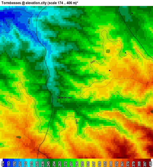
Below is the Elevation map of Torrebesses, which displays elevation range with different colors. Scale of the first map is from 174 to 406 m (571 to 1332 ft) with average elevation of 287.2 meters (=942 ft) [note 1]
These maps also provides idea of topography and contour of this city, they are displayed at different zoom levels. More info about maps, scale and edge coordinates you can find below images.
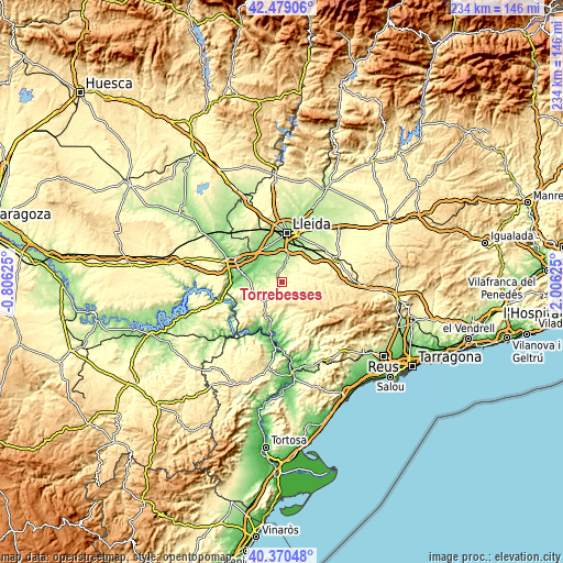
| \ | Map #1 | Topo.Map |
| Scale [m] | 174..406 m | × |
| Scale [ft] | 571..1332 ft | × |
| Average | 287.2 m = 942 ft | × |
| Width | 7.33 km = 4.6 mi | 234.5 km = 145.7 mi |
| Height | 7.33 km = 4.6 mi | 234.4 km = 145.6 mi |
| ↑Max Latitude | 41.466269° | 42.47906° |
| Latitude at center | 41.43333° | 41.43333° |
| ↓Min Latitude | 41.400375° | 40.37048° |
| ← Min Longitude | 0.556055° | -0.80625° |
| Longitude center | 0.6° | 0.6° |
| →Max Longitude | 0.643945° | 2.00625° |
Nearby cities:
Cities around Torrebesses sort by population:
• Aitona elevation 102 m
12.4 km,  296°
296°
• Torres de Segre 126 m
13.3 km,  327°
327°
• Seròs 102 m
15.7 km,  283°
283°
• Soses 137 m
14.8 km,  318°
318°
• la Granadella 536 m
10.8 km,  149°
149°
• Alfés 236 m
9.9 km,  9°
9°
• Aspa 263 m
9.1 km,  41°
41°
• Alcanó 221 m
5.4 km, 14°
• Bovera 310 m
13.6 km,  162°
162°
• Maials 364 m
11.2 km,  228°
228°
• Sunyer 174 m
10 km,  356°
356°
• el Cogul 297 m
7.9 km,  61°
61°
Multilingual:
 En español:
Torrebeses elevación 288 m.
 En France:
Torrebesses élévation 288 m.
 Auf Deutsch:
Torrebesses höhe über dem Meeresspiegel ist 288 m.

Sources and notes:
- [note 1] Map square and city borders are not equal. Map elevation data is calculated only from area inside that square.
- [src 1] Elevation data from geonames database provided with same terms of usage.
- [src 2] The elevation map of Torrebesses is generated using elevation data from NASA's 3 arcsec (90m) resolution SRTM data.
- [src 3] Base (background) map © OpenStreetMap contributors tiles are generated by Geofabrik and OpenTopoMap.
Copyright & License:
This Torrebesses Elevation Map is licensed under CC BY-SA. You may reuse any part from this page, if you give a proper credit by linking to this URL:
 More info on terms of use page.