Torreiglesias elevation
Torreiglesias (Castille and León, Provincia de Segovia), Spain elevation is 1021 meters and Torreiglesias elevation in feet is 3350 ft above sea level [src 1]. Torreiglesias is a seat of a third-order administrative division (feature code) with elevation that is 418 meters (1371 ft) bigger than average city elevation in Spain.
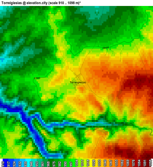
Below is the Elevation map of Torreiglesias, which displays elevation range with different colors. Scale of the first map is from 910 to 1098 m (2986 to 3602 ft) with average elevation of 1003.7 meters (=3293 ft) [note 1]
These maps also provides idea of topography and contour of this city, they are displayed at different zoom levels. More info about maps, scale and edge coordinates you can find below images.
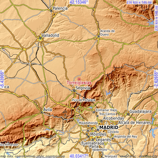
| \ | Map #1 | Topo.Map |
| Scale [m] | 910..1098 m | × |
| Scale [ft] | 2986..3602 ft | × |
| Average | 1003.7 m = 3293 ft | × |
| Width | 7.36 km = 4.6 mi | 235.6 km = 146.4 mi |
| Height | 7.36 km = 4.6 mi | 235.6 km = 146.4 mi |
| ↑Max Latitude | 41.135466° | 42.15346° |
| Latitude at center | 41.10236° | 41.10236° |
| ↓Min Latitude | 41.069237° | 40.03417° |
| ← Min Longitude | -4.076745° | -5.43905° |
| Longitude center | -4.0328° | -4.0328° |
| →Max Longitude | -3.988855° | -2.62655° |
Nearby cities:
Cities around Torreiglesias sort by population:
• La Cuesta elevation 1123 m
6.5 km,  109°
109°
• Turégano 940 m
6.4 km,  19°
19°
• Escalona del Prado 894 m
10.4 km,  313°
313°
• Escobar de Polendos 906 m
8.3 km,  261°
261°
• Muñoveros 960 m
10.3 km,  41°
41°
• Basardilla 1094 m
8.4 km,  176°
176°
• Cabañas de Polendos 943 m
7.6 km,  238°
238°
• Caballar 1006 m
6.1 km,  69°
69°
• Brieva 1092 m
7.7 km,  193°
193°
• Santo Domingo de Pirón 1083 m
7.7 km,  151°
151°
• Pelayos del Arroyo 1145 m
9.6 km,  126°
126°
• Adrada de Pirón 1022 m
5.7 km,  195°
195°
Multilingual:
 En español:
Torreiglesias elevación 1021 m.
 En France:
Torreiglesias élévation 1021 m.
 Auf Deutsch:
Torreiglesias höhe über dem Meeresspiegel ist 1021 m.

Sources and notes:
- [note 1] Map square and city borders are not equal. Map elevation data is calculated only from area inside that square.
- [src 1] Elevation data from geonames database provided with same terms of usage.
- [src 2] The elevation map of Torreiglesias is generated using elevation data from NASA's 3 arcsec (90m) resolution SRTM data.
- [src 3] Base (background) map © OpenStreetMap contributors tiles are generated by Geofabrik and OpenTopoMap.
Copyright & License:
This Torreiglesias Elevation Map is licensed under CC BY-SA. You may reuse any part from this page, if you give a proper credit by linking to this URL:
 More info on terms of use page.