Utande elevation
Utande (Castille-La Mancha, Provincia de Guadalajara), Spain elevation is 839 meters and Utande elevation in feet is 2753 ft above sea level [src 1]. Utande is a seat of a third-order administrative division (feature code) with elevation that is 236 meters (774 ft) bigger than average city elevation in Spain.
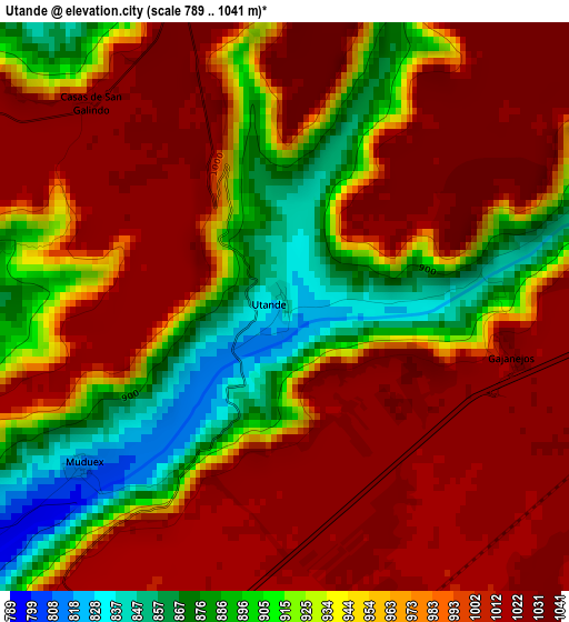
Below is the Elevation map of Utande, which displays elevation range with different colors. Scale of the first map is from 789 to 1041 m (2589 to 3415 ft) with average elevation of 965.7 meters (=3168 ft) [note 1]
These maps also provides idea of topography and contour of this city, they are displayed at different zoom levels. More info about maps, scale and edge coordinates you can find below images.
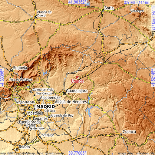
| \ | Map #1 | Topo.Map |
| Scale [m] | 789..1041 m | × |
| Scale [ft] | 2589..3415 ft | × |
| Average | 965.7 m = 3168 ft | × |
| Width | 7.39 km = 4.6 mi | 236.6 km = 147 mi |
| Height | 7.39 km = 4.6 mi | 236.5 km = 147 mi |
| ↑Max Latitude | 40.881554° | 41.90352° |
| Latitude at center | 40.84832° | 40.84832° |
| ↓Min Latitude | 40.81507° | 39.77605° |
| ← Min Longitude | -2.971645° | -4.33395° |
| Longitude center | -2.9277° | -2.9277° |
| →Max Longitude | -2.883755° | -1.52145° |
Nearby cities:
Cities around Utande sort by population:
• Jadraque elevation 825 m
8.5 km,  1°
1°
• Trijueque 999 m
9.9 km,  213°
213°
• Hita 815 m
10.3 km,  253°
253°
• Muduex 813 m
3.4 km,  231°
231°
• Ledanca 911 m
7.4 km,  72°
72°
• Argecilla 972 m
9.6 km, 67°
• Valdearenas 790 m
6.9 km, 231°
• Bujalaro 847 m
10.5 km,  20°
20°
• Miralrío 1037 m
4.7 km,  343°
343°
• Gajanejos 1033 m
3.1 km,  104°
104°
• Villanueva de Argecilla 1024 m
6.1 km,  10°
10°
• Casas de San Galindo 1030 m
3.7 km,  316°
316°
Multilingual:
 En español:
Utande elevación 839 m.
 En France:
Utande élévation 839 m.


Sources and notes:
- [note 1] Map square and city borders are not equal. Map elevation data is calculated only from area inside that square.
- [src 1] Elevation data from geonames database provided with same terms of usage.
- [src 2] The elevation map of Utande is generated using elevation data from NASA's 3 arcsec (90m) resolution SRTM data.
- [src 3] Base (background) map © OpenStreetMap contributors tiles are generated by Geofabrik and OpenTopoMap.
Copyright & License:
This Utande Elevation Map is licensed under CC BY-SA. You may reuse any part from this page, if you give a proper credit by linking to this URL:
 More info on terms of use page.