Utebo elevation
Utebo (Aragon, Provincia de Zaragoza), Spain elevation is 213 meters and Utebo elevation in feet is 699 ft above sea level [src 1]. Utebo is a seat of a third-order administrative division (feature code) with elevation that is 390 meters (1280 ft) smaller than average city elevation in Spain.
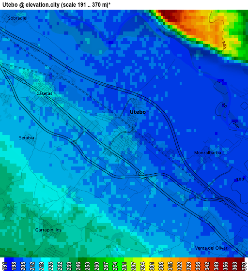
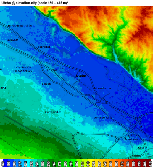
Below is the Elevation map of Utebo, which displays elevation range with different colors. Scale of the first map is from 191 to 370 m (627 to 1214 ft) with average elevation of 215.6 meters (=707 ft) [note 1]
These maps also provides idea of topography and contour of this city, they are displayed at different zoom levels. More info about maps, scale and edge coordinates you can find below images.
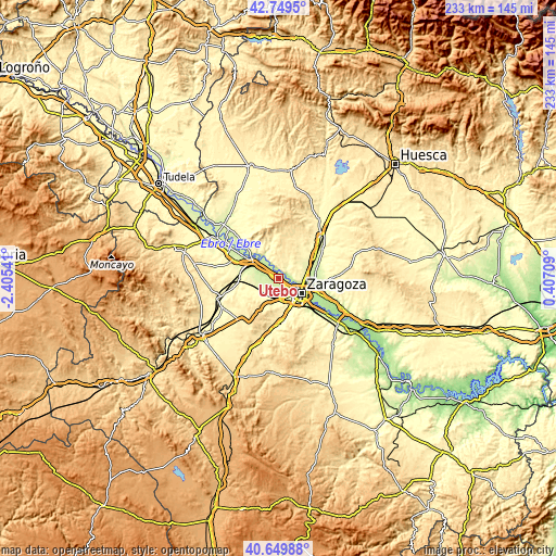
| \ | Map #1 | Map #2 | Topo.Map |
| Scale [m] | 191..370 m | 189..415 m | × |
| Scale [ft] | 627..1214 ft | 620..1362 ft | × |
| Average | 215.6 m = 707 ft | 247.8 m = 813 ft | × |
| Width | 7.3 km = 4.5 mi | 14.59 km = 9.1 mi | 233.5 km = 145.1 mi |
| Height | 7.3 km = 4.5 mi | 14.59 km = 9.1 mi | 233.4 km = 145 mi |
| ↑Max Latitude | 41.741059° | 41.773841° | 42.7495° |
| Latitude at center | 41.70826° | 41.70826° | 41.70826° |
| ↓Min Latitude | 41.675445° | 41.642612° | 40.64988° |
| ← Min Longitude | -1.043105° | -1.087051° | -2.40541° |
| Longitude center | -0.99916° | -0.99916° | -0.99916° |
| →Max Longitude | -0.955215° | -0.911269° | 0.40709° |
Nearby cities:
Cities around Utebo sort by population:
• Zaragoza elevation 214 m
11.7 km,  119°
119°
• Delicias 228 m
10 km,  130°
130°
• Oliver-Valdefierro 240 m
8.9 km,  142°
142°
• Almozara 205 m
9.6 km, 122°
• Montecanal 259 m
10.1 km,  150°
150°
• Alagón 232 m
12.1 km,  304°
304°
• Cuarte de Huerva 262 m
13.8 km,  156°
156°
• Pinseque 230 m
9 km,  290°
290°
• Torres de Berrellén 216 m
7.8 km,  315°
315°
• Sobradiel 213 m
4.7 km, 316°
• Grisén 246 m
14.2 km, 286°
• Bárboles 273 m
15.5 km,  270°
270°
Multilingual:
 En español:
Utebo elevación 213 m.
 En France:
Utebo élévation 213 m.


Sources and notes:
- [note 1] Map square and city borders are not equal. Map elevation data is calculated only from area inside that square.
- [src 1] Elevation data from geonames database provided with same terms of usage.
- [src 2] The elevation map of Utebo is generated using elevation data from NASA's 3 arcsec (90m) resolution SRTM data.
- [src 3] Base (background) map © OpenStreetMap contributors tiles are generated by Geofabrik and OpenTopoMap.
Copyright & License:
This Utebo Elevation Map is licensed under CC BY-SA. You may reuse any part from this page, if you give a proper credit by linking to this URL:
 More info on terms of use page.