Valdaracete elevation
Valdaracete (Madrid, Provincia de Madrid), Spain elevation is 750 meters and Valdaracete elevation in feet is 2461 ft above sea level [src 1]. Valdaracete is a seat of a third-order administrative division (feature code) with elevation that is 147 meters (482 ft) bigger than average city elevation in Spain.
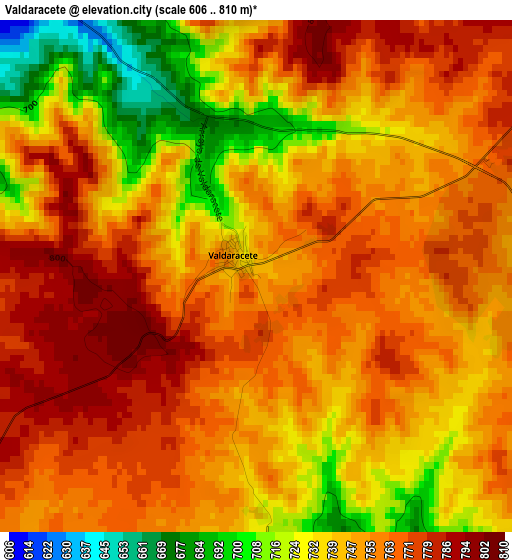
Below is the Elevation map of Valdaracete, which displays elevation range with different colors. Scale of the first map is from 606 to 810 m (1988 to 2657 ft) with average elevation of 750.5 meters (=2462 ft) [note 1]
These maps also provides idea of topography and contour of this city, they are displayed at different zoom levels. More info about maps, scale and edge coordinates you can find below images.
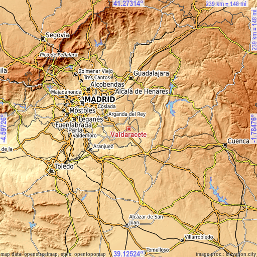
| \ | Map #1 | Topo.Map |
| Scale [m] | 606..810 m | × |
| Scale [ft] | 1988..2657 ft | × |
| Average | 750.5 m = 2462 ft | × |
| Width | 7.46 km = 4.6 mi | 238.8 km = 148.4 mi |
| Height | 7.46 km = 4.6 mi | 238.8 km = 148.4 mi |
| ↑Max Latitude | 40.241253° | 41.27314° |
| Latitude at center | 40.2077° | 40.2077° |
| ↓Min Latitude | 40.17413° | 39.12524° |
| ← Min Longitude | -3.234955° | -4.59726° |
| Longitude center | -3.19101° | -3.19101° |
| →Max Longitude | -3.147065° | -1.78476° |
Nearby cities:
Cities around Valdaracete sort by population:
• Villarejo de Salvanés elevation 755 m
8.3 km,  236°
236°
• Mondéjar 821 m
14.5 km,  29°
29°
• Perales de Tajuña 582 m
13.8 km,  280°
280°
• Tielmes 599 m
11.3 km,  292°
292°
• Valdilecha 705 m
13.6 km,  315°
315°
• Villar del Olmo 672 m
14.6 km,  345°
345°
• Fuentidueña de Tajo 552 m
10.6 km,  164°
164°
• Carabaña 618 m
6.4 km, 323°
• Estremera 626 m
8.2 km,  109°
109°
• Brea de Tajo 676 m
8.2 km,  69°
69°
• Ambite 680 m
13.8 km,  3°
3°
• Driebes 729 m
13.3 km, 71°
Multilingual:
 En español:
Valdaracete elevación 750 m.
 En France:
Valdaracete élévation 750 m.
 Auf Deutsch:
Valdaracete höhe über dem Meeresspiegel ist 750 m.

Sources and notes:
- [note 1] Map square and city borders are not equal. Map elevation data is calculated only from area inside that square.
- [src 1] Elevation data from geonames database provided with same terms of usage.
- [src 2] The elevation map of Valdaracete is generated using elevation data from NASA's 3 arcsec (90m) resolution SRTM data.
- [src 3] Base (background) map © OpenStreetMap contributors tiles are generated by Geofabrik and OpenTopoMap.
Copyright & License:
This Valdaracete Elevation Map is licensed under CC BY-SA. You may reuse any part from this page, if you give a proper credit by linking to this URL:
 More info on terms of use page.