Valdecasa elevation
Valdecasa (Castille and León, Provincia de Ávila), Spain elevation is 1368 meters and Valdecasa elevation in feet is 4488 ft above sea level [src 1]. Valdecasa is a seat of a third-order administrative division (feature code) with elevation that is 765 meters (2510 ft) bigger than average city elevation in Spain.
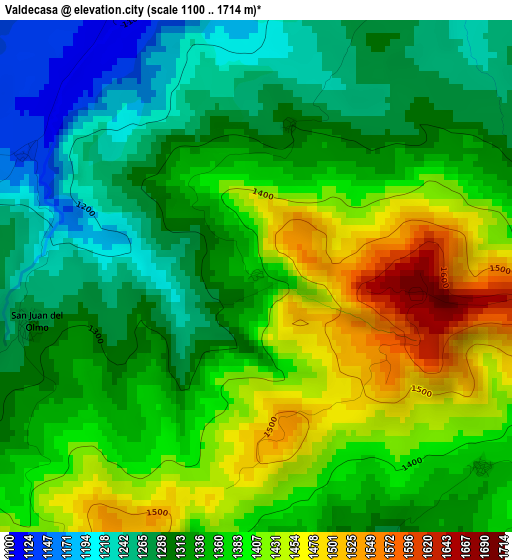
Below is the Elevation map of Valdecasa, which displays elevation range with different colors. Scale of the first map is from 1100 to 1714 m (3609 to 5623 ft) with average elevation of 1350.1 meters (=4429 ft) [note 1]
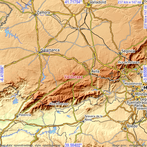
These maps also provides idea of topography and contour of this city, they are displayed at different zoom levels. More info about maps, scale and edge coordinates you can find below images.
| \ | Map #1 | Topo.Map |
| Scale [m] | 1100..1714 m | × |
| Scale [ft] | 3609..5623 ft | × |
| Average | 1350.1 m = 4429 ft | × |
| Width | 7.41 km = 4.6 mi | 237.2 km = 147.4 mi |
| Height | 7.41 km = 4.6 mi | 237.2 km = 147.4 mi |
| ↑Max Latitude | 40.692638° | 41.71754° |
| Latitude at center | 40.65931° | 40.65931° |
| ↓Min Latitude | 40.625965° | 39.58402° |
| ← Min Longitude | -5.055775° | -6.41808° |
| Longitude center | -5.01183° | -5.01183° |
| →Max Longitude | -4.967885° | -3.60558° |
Nearby cities:
Cities around Valdecasa sort by population:
• Muñana elevation 1172 m
7.7 km,  181°
181°
• Muñogalindo 1134 m
11.4 km,  123°
123°
• Amavida 1176 m
10.5 km,  205°
205°
• Sanchorreja 1312 m
8.2 km,  85°
85°
• Cillán 1196 m
5.9 km,  25°
25°
• Muñico 1090 m
5.4 km,  346°
346°
• Vadillo de la Sierra 1353 m
11.2 km,  238°
238°
• Hurtumpascual 1177 m
9.3 km,  292°
292°
• Chamartín 1195 m
6.6 km,  43°
43°
• Gallegos de Sobrinos 1165 m
10.6 km,  307°
307°
• Narrillos del Rebollar 1380 m
3.9 km,  80°
80°
• Manjabálago 1289 m
5.5 km,  275°
275°
Multilingual:
 En español:
Valdecasa elevación 1368 m.
 En France:
Valdecasa élévation 1368 m.
 Auf Deutsch:
Valdecasa höhe über dem Meeresspiegel ist 1368 m.

Sources and notes:
- [note 1] Map square and city borders are not equal. Map elevation data is calculated only from area inside that square.
- [src 1] Elevation data from geonames database provided with same terms of usage.
- [src 2] The elevation map of Valdecasa is generated using elevation data from NASA's 3 arcsec (90m) resolution SRTM data.
- [src 3] Base (background) map © OpenStreetMap contributors tiles are generated by Geofabrik and OpenTopoMap.
Copyright & License:
This Valdecasa Elevation Map is licensed under CC BY-SA. You may reuse any part from this page, if you give a proper credit by linking to this URL:
 More info on terms of use page.