Valdevimbre elevation
Valdevimbre (Castille and León, Provincia de León), Spain elevation is 811 meters and Valdevimbre elevation in feet is 2661 ft above sea level [src 1]. Valdevimbre is a seat of a third-order administrative division (feature code) with elevation that is 208 meters (682 ft) bigger than average city elevation in Spain.
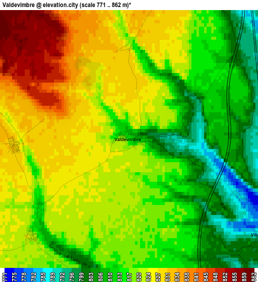
Below is the Elevation map of Valdevimbre, which displays elevation range with different colors. Scale of the first map is from 771 to 862 m (2530 to 2828 ft) with average elevation of 818.7 meters (=2686 ft) [note 1]
These maps also provides idea of topography and contour of this city, they are displayed at different zoom levels. More info about maps, scale and edge coordinates you can find below images.
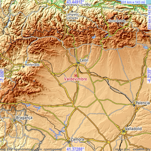
| \ | Map #1 | Topo.Map |
| Scale [m] | 771..862 m | × |
| Scale [ft] | 2530..2828 ft | × |
| Average | 818.7 m = 2686 ft | × |
| Width | 7.21 km = 4.5 mi | 230.9 km = 143.5 mi |
| Height | 7.21 km = 4.5 mi | 230.8 km = 143.4 mi |
| ↑Max Latitude | 42.452023° | 43.44912° |
| Latitude at center | 42.41959° | 42.41959° |
| ↓Min Latitude | 42.38714° | 41.37288° |
| ← Min Longitude | -5.663695° | -7.026° |
| Longitude center | -5.61975° | -5.61975° |
| →Max Longitude | -5.575805° | -4.2135° |
Nearby cities:
Cities around Valdevimbre sort by population:
• Chozas de Abajo elevation 882 m
11.1 km,  330°
330°
• Onzonilla 808 m
12.1 km,  15°
15°
• Villamañán 762 m
11.3 km,  164°
164°
• Vega de Infanzones 780 m
9.9 km,  46°
46°
• Bercianos del Páramo 815 m
8.5 km,  238°
238°
• Fresno de la Vega 755 m
10.7 km,  140°
140°
• Ardón 780 m
5.2 km,  69°
69°
• Villanueva de las Manzanas 780 m
12.9 km,  62°
62°
• Cabreros del Río 763 m
6.7 km,  106°
106°
• San Pedro Bercianos 822 m
8.3 km,  247°
247°
• Campo de Villavidel 770 m
7.8 km, 73°
• Cubillas de los Oteros 776 m
10.5 km,  120°
120°
Multilingual:
 En español:
Valdevimbre elevación 811 m.
 En France:
Valdevimbre élévation 811 m.
 Auf Deutsch:
Valdevimbre höhe über dem Meeresspiegel ist 811 m.

Sources and notes:
- [note 1] Map square and city borders are not equal. Map elevation data is calculated only from area inside that square.
- [src 1] Elevation data from geonames database provided with same terms of usage.
- [src 2] The elevation map of Valdevimbre is generated using elevation data from NASA's 3 arcsec (90m) resolution SRTM data.
- [src 3] Base (background) map © OpenStreetMap contributors tiles are generated by Geofabrik and OpenTopoMap.
Copyright & License:
This Valdevimbre Elevation Map is licensed under CC BY-SA. You may reuse any part from this page, if you give a proper credit by linking to this URL:
 More info on terms of use page.