Vallromanes elevation
Vallromanes (Catalonia, Província de Barcelona), Spain elevation is 168 meters and Vallromanes elevation in feet is 551 ft above sea level [src 1]. Vallromanes is a seat of a third-order administrative division (feature code) with elevation that is 435 meters (1427 ft) smaller than average city elevation in Spain.
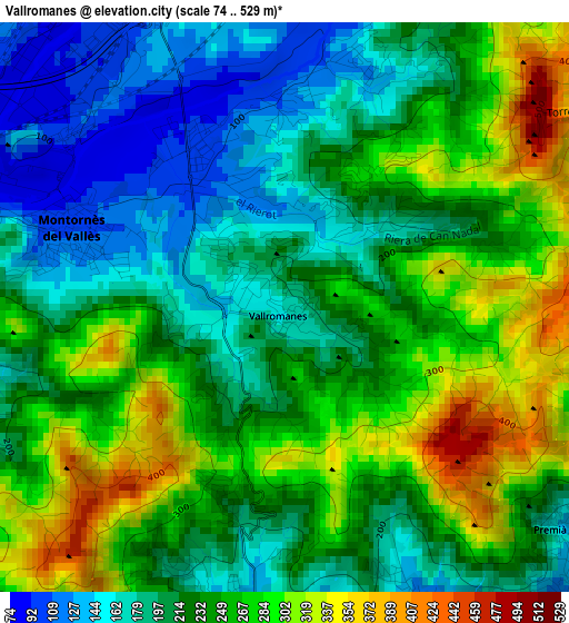
Below is the Elevation map of Vallromanes, which displays elevation range with different colors. Scale of the first map is from 74 to 529 m (243 to 1736 ft) with average elevation of 234.7 meters (=770 ft) [note 1]
These maps also provides idea of topography and contour of this city, they are displayed at different zoom levels. More info about maps, scale and edge coordinates you can find below images.
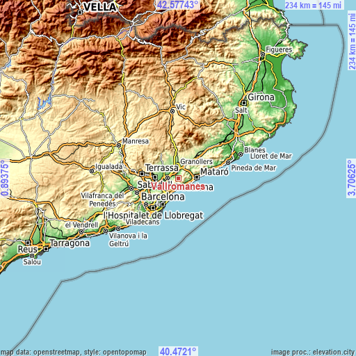
| \ | Map #1 | Topo.Map |
| Scale [m] | 74..529 m | × |
| Scale [ft] | 243..1736 ft | × |
| Average | 234.7 m = 770 ft | × |
| Width | 7.32 km = 4.5 mi | 234.1 km = 145.5 mi |
| Height | 7.32 km = 4.5 mi | 234.1 km = 145.5 mi |
| ↑Max Latitude | 41.566218° | 42.57743° |
| Latitude at center | 41.53333° | 41.53333° |
| ↓Min Latitude | 41.500425° | 40.4721° |
| ← Min Longitude | 2.256055° | 0.89375° |
| Longitude center | 2.3° | 2.3° |
| →Max Longitude | 2.343945° | 3.70625° |
Nearby cities:
Cities around Vallromanes sort by population:
• Mollet del Vallès elevation 73 m
7.3 km,  276°
276°
• Premià de Mar 6 m
7.1 km,  130°
130°
• El Masnou 12 m
6.2 km,  165°
165°
• Parets del Vallès 99 m
7.2 km,  309°
309°
• Montornès del Vallès 100 m
2.9 km,  289°
289°
• La Roca del Vallès 198 m
6.2 km,  26°
26°
• Alella 98 m
4.4 km,  185°
185°
• Montmeló 78 m
5.2 km, 290°
• Tiana 115 m
6.3 km,  205°
205°
• Cabrils 179 m
5.9 km,  96°
96°
• Teià 108 m
4.3 km,  154°
154°
• Òrrius 281 m
4.6 km,  65°
65°
Multilingual:
 En español:
Vallromanas elevación 168 m.
 En France:
Vallromanes élévation 168 m.
 Auf Deutsch:
Vallromanes höhe über dem Meeresspiegel ist 168 m.

Sources and notes:
- [note 1] Map square and city borders are not equal. Map elevation data is calculated only from area inside that square.
- [src 1] Elevation data from geonames database provided with same terms of usage.
- [src 2] The elevation map of Vallromanes is generated using elevation data from NASA's 3 arcsec (90m) resolution SRTM data.
- [src 3] Base (background) map © OpenStreetMap contributors tiles are generated by Geofabrik and OpenTopoMap.
Copyright & License:
This Vallromanes Elevation Map is licensed under CC BY-SA. You may reuse any part from this page, if you give a proper credit by linking to this URL:
 More info on terms of use page.