Valverde-Enrique elevation
Valverde-Enrique (Castille and León, Provincia de León), Spain elevation is 835 meters and Valverde-Enrique elevation in feet is 2740 ft above sea level [src 1]. Valverde-Enrique is a seat of a third-order administrative division (feature code) with elevation that is 232 meters (761 ft) bigger than average city elevation in Spain.
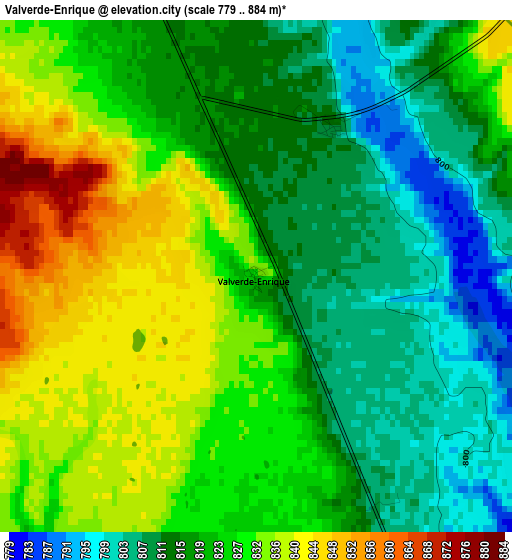
Below is the Elevation map of Valverde-Enrique, which displays elevation range with different colors. Scale of the first map is from 779 to 884 m (2556 to 2900 ft) with average elevation of 822.5 meters (=2698 ft) [note 1]
These maps also provides idea of topography and contour of this city, they are displayed at different zoom levels. More info about maps, scale and edge coordinates you can find below images.
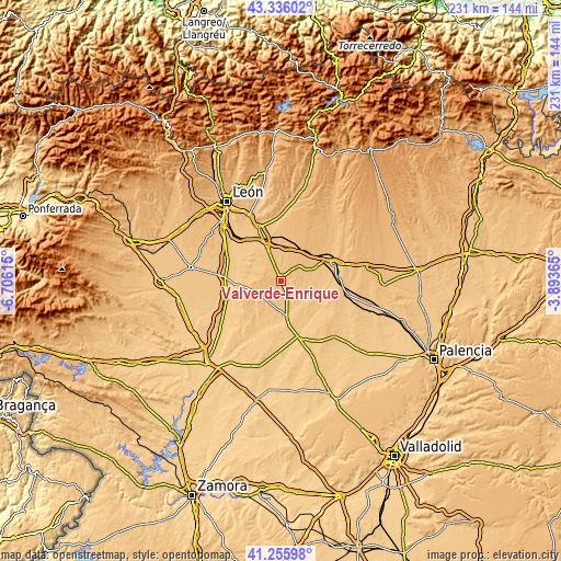
| \ | Map #1 | Topo.Map |
| Scale [m] | 779..884 m | × |
| Scale [ft] | 2556..2900 ft | × |
| Average | 822.5 m = 2698 ft | × |
| Width | 7.23 km = 4.5 mi | 231.3 km = 143.7 mi |
| Height | 7.23 km = 4.5 mi | 231.3 km = 143.7 mi |
| ↑Max Latitude | 42.337083° | 43.33602° |
| Latitude at center | 42.30459° | 42.30459° |
| ↓Min Latitude | 42.272081° | 41.25598° |
| ← Min Longitude | -5.343845° | -6.70615° |
| Longitude center | -5.2999° | -5.2999° |
| →Max Longitude | -5.255955° | -3.89365° |
Nearby cities:
Cities around Valverde-Enrique sort by population:
• Joarilla de las Matas elevation 796 m
10.2 km,  100°
100°
• Santa Cristina de Valmadrigal 814 m
5.6 km,  352°
352°
• Gordaliza del Pino 824 m
12.5 km,  69°
69°
• Matadeón de los Oteros 859 m
6.8 km,  303°
303°
• Izagre 785 m
9.6 km,  158°
158°
• Gusendos de los Oteros 797 m
13.5 km,  307°
307°
• Saelices de Mayorga 778 m
12.9 km,  142°
142°
• Villamoratiel de las Matas 848 m
10.3 km,  359°
359°
• Vallecillo 842 m
9.3 km,  51°
51°
• Villabraz 847 m
13.6 km,  241°
241°
• Monasterio de Vega 773 m
12.8 km,  130°
130°
• Castilfalé 828 m
13.7 km,  226°
226°
Multilingual:
 En español:
Valverde-Enrique elevación 835 m.
 En France:
Valverde-Enrique élévation 835 m.
 Auf Deutsch:
Valverde-Enrique höhe über dem Meeresspiegel ist 835 m.

Sources and notes:
- [note 1] Map square and city borders are not equal. Map elevation data is calculated only from area inside that square.
- [src 1] Elevation data from geonames database provided with same terms of usage.
- [src 2] The elevation map of Valverde-Enrique is generated using elevation data from NASA's 3 arcsec (90m) resolution SRTM data.
- [src 3] Base (background) map © OpenStreetMap contributors tiles are generated by Geofabrik and OpenTopoMap.
Copyright & License:
This Valverde-Enrique Elevation Map is licensed under CC BY-SA. You may reuse any part from this page, if you give a proper credit by linking to this URL:
 More info on terms of use page.