Ventrosa elevation
Ventrosa (La Rioja, Provincia de La Rioja), Spain elevation is 977 meters and Ventrosa elevation in feet is 3205 ft above sea level [src 1]. Ventrosa is a seat of a third-order administrative division (feature code) with elevation that is 374 meters (1227 ft) bigger than average city elevation in Spain.
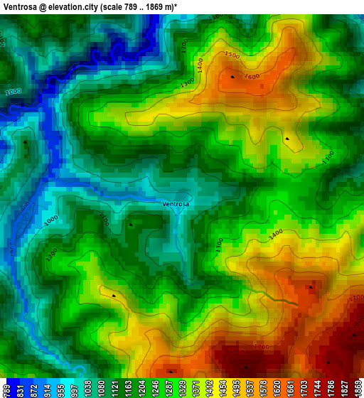
Below is the Elevation map of Ventrosa, which displays elevation range with different colors. Scale of the first map is from 789 to 1869 m (2589 to 6132 ft) with average elevation of 1256 meters (=4121 ft) [note 1]
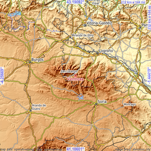
These maps also provides idea of topography and contour of this city, they are displayed at different zoom levels. More info about maps, scale and edge coordinates you can find below images.
| \ | Map #1 | Topo.Map |
| Scale [m] | 789..1869 m | × |
| Scale [ft] | 2589..6132 ft | × |
| Average | 1256 m = 4121 ft | × |
| Width | 7.24 km = 4.5 mi | 231.8 km = 144 mi |
| Height | 7.24 km = 4.5 mi | 231.8 km = 144 mi |
| ↑Max Latitude | 42.189619° | 43.19092° |
| Latitude at center | 42.15705° | 42.15705° |
| ↓Min Latitude | 42.124465° | 41.10601° |
| ← Min Longitude | -2.894385° | -4.25669° |
| Longitude center | -2.85044° | -2.85044° |
| →Max Longitude | -2.806495° | -1.44419° |
Nearby cities:
Cities around Ventrosa sort by population:
• Anguiano elevation 640 m
13.8 km,  30°
30°
• Villoslada de Cameros 1077 m
15.3 km,  108°
108°
• Neila 1175 m
16.2 km,  228°
228°
• Matute 678 m
16.4 km,  15°
15°
• Viniegra de Abajo 887 m
3.3 km,  257°
257°
• Montenegro de Cameros 1232 m
11 km,  133°
133°
• Canales de la Sierra 1020 m
14.4 km, 263°
• Tobía 683 m
16 km,  10°
10°
• Villavelayo 938 m
11.5 km, 255°
• Brieva de Cameros 978 m
4.7 km,  79°
79°
• Viniegra de Arriba 1184 m
7 km,  168°
168°
• Ortigosa 1055 m
12.2 km, 80°
Multilingual:
 En español:
Ventrosa elevación 977 m.
 En France:
Ventrosa élévation 977 m.
 Auf Deutsch:
Ventrosa höhe über dem Meeresspiegel ist 977 m.

Sources and notes:
- [note 1] Map square and city borders are not equal. Map elevation data is calculated only from area inside that square.
- [src 1] Elevation data from geonames database provided with same terms of usage.
- [src 2] The elevation map of Ventrosa is generated using elevation data from NASA's 3 arcsec (90m) resolution SRTM data.
- [src 3] Base (background) map © OpenStreetMap contributors tiles are generated by Geofabrik and OpenTopoMap.
Copyright & License:
This Ventrosa Elevation Map is licensed under CC BY-SA. You may reuse any part from this page, if you give a proper credit by linking to this URL:
 More info on terms of use page.