Vielha elevation
Vielha (Catalonia, Província de Lleida), Spain elevation is 976 meters and Vielha elevation in feet is 3202 ft above sea level [src 1]. Vielha is a populated place (feature code) with elevation that is 373 meters (1224 ft) bigger than average city elevation in Spain.
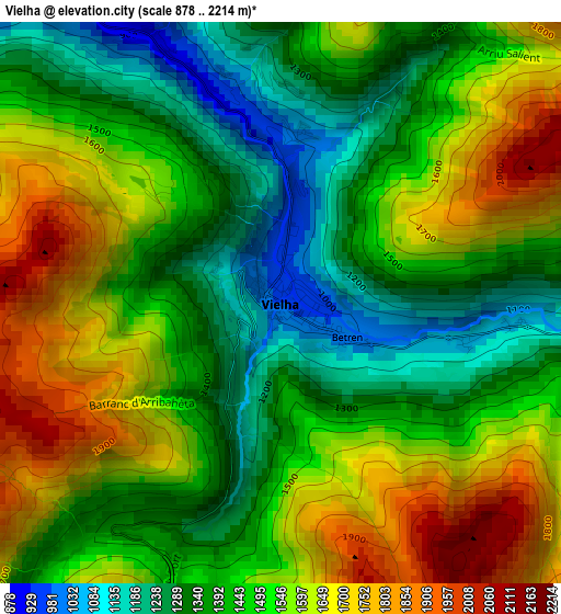
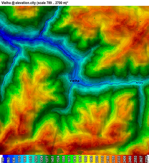
Below is the Elevation map of Vielha, which displays elevation range with different colors. Scale of the first map is from 878 to 2214 m (2881 to 7264 ft) with average elevation of 1489.7 meters (=4887 ft) [note 1]
These maps also provides idea of topography and contour of this city, they are displayed at different zoom levels. More info about maps, scale and edge coordinates you can find below images.
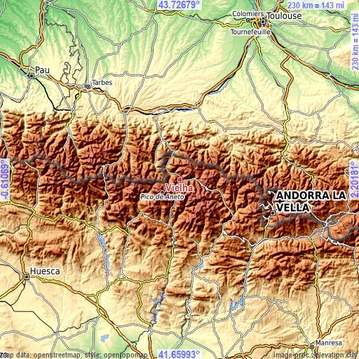
| \ | Map #1 | Map #2 | Topo.Map |
| Scale [m] | 878..2214 m | 789..2700 m | × |
| Scale [ft] | 2881..7264 ft | 2589..8858 ft | × |
| Average | 1489.7 m = 4887 ft | 1746.7 m = 5731 ft | × |
| Width | 7.18 km = 4.5 mi | 14.36 km = 8.9 mi | 229.8 km = 142.8 mi |
| Height | 7.18 km = 4.5 mi | 14.36 km = 8.9 mi | 229.8 km = 142.8 mi |
| ↑Max Latitude | 42.734247° | 42.766516° | 43.72679° |
| Latitude at center | 42.70196° | 42.70196° | 42.70196° |
| ↓Min Latitude | 42.669657° | 42.637336° | 41.65993° |
| ← Min Longitude | 0.751615° | 0.707669° | -0.61069° |
| Longitude center | 0.79556° | 0.79556° | 0.79556° |
| →Max Longitude | 0.839505° | 0.883451° | 2.20181° |
Nearby cities:
Cities around Vielha sort by population:
• Benasque elevation 1140 m
24.7 km,  244°
244°
• Castejón de Sos 919 m
32.6 km,  229°
229°
• Les 638 m
13.9 km,  330°
330°
• Espot 1340 m
27.5 km,  119°
119°
• Sahún 1097 m
30.4 km, 242°
• Laspaúles 1457 m
30.4 km,  212°
212°
• Bisaurri 1119 m
32.9 km, 226°
• Seira 813 m
38.9 km, 230°
• Sesué 1009 m
31.3 km, 237°
• Chía 1206 m
33.7 km, 233°
• Bonansa 1244 m
32.3 km,  199°
199°
• Villanova 997 m
32.3 km, 237°
Multilingual:
 En español:
Viella Mitg Arán elevación 976 m.
 En France:
Vielha élévation 976 m.
 Auf Deutsch:
Vielha e Mijaran höhe über dem Meeresspiegel ist 976 m.

Sources and notes:
- [note 1] Map square and city borders are not equal. Map elevation data is calculated only from area inside that square.
- [src 1] Elevation data from geonames database provided with same terms of usage.
- [src 2] The elevation map of Vielha is generated using elevation data from NASA's 3 arcsec (90m) resolution SRTM data.
- [src 3] Base (background) map © OpenStreetMap contributors tiles are generated by Geofabrik and OpenTopoMap.
Copyright & License:
This Vielha Elevation Map is licensed under CC BY-SA. You may reuse any part from this page, if you give a proper credit by linking to this URL:
 More info on terms of use page.