Villabáñez elevation
Villabáñez (Castille and León, Provincia de Valladolid), Spain elevation is 742 meters and Villabáñez elevation in feet is 2434 ft above sea level [src 1]. Villabáñez is a seat of a third-order administrative division (feature code) with elevation that is 139 meters (456 ft) bigger than average city elevation in Spain.
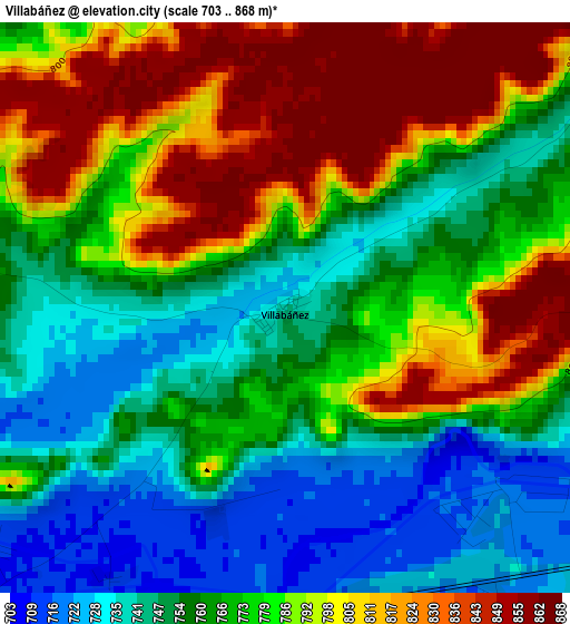
Below is the Elevation map of Villabáñez, which displays elevation range with different colors. Scale of the first map is from 703 to 868 m (2306 to 2848 ft) with average elevation of 775.7 meters (=2545 ft) [note 1]
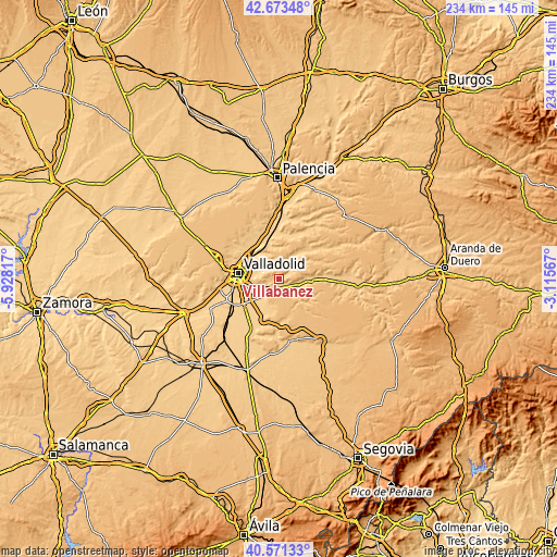
These maps also provides idea of topography and contour of this city, they are displayed at different zoom levels. More info about maps, scale and edge coordinates you can find below images.
| \ | Map #1 | Topo.Map |
| Scale [m] | 703..868 m | × |
| Scale [ft] | 2306..2848 ft | × |
| Average | 775.7 m = 2545 ft | × |
| Width | 7.3 km = 4.5 mi | 233.7 km = 145.2 mi |
| Height | 7.3 km = 4.5 mi | 233.7 km = 145.2 mi |
| ↑Max Latitude | 41.663808° | 42.67348° |
| Latitude at center | 41.63097° | 41.63097° |
| ↓Min Latitude | 41.598115° | 40.57133° |
| ← Min Longitude | -4.565865° | -5.92817° |
| Longitude center | -4.52192° | -4.52192° |
| →Max Longitude | -4.477975° | -3.11567° |
Nearby cities:
Cities around Villabáñez sort by population:
• Tudela de Duero elevation 706 m
7.1 km,  223°
223°
• Cistérniga 743 m
13.9 km,  261°
261°
• Quintanilla de Onésimo 730 m
13.2 km,  92°
92°
• Traspinedo 741 m
7.3 km,  148°
148°
• Sardón de Duero 723 m
7.7 km,  108°
108°
• Piña de Esgueva 748 m
13.3 km,  35°
35°
• Castronuevo de Esgueva 756 m
7.9 km,  315°
315°
• Olivares de Duero 735 m
13 km, 86°
• Villavaquerín 764 m
6.1 km,  53°
53°
• Olmos de Esgueva 731 m
6.4 km,  359°
359°
• Santibáñez de Valcorba 750 m
9.1 km,  138°
138°
• Villarmentero de Esgueva 731 m
6.4 km,  341°
341°
Multilingual:
 En español:
Villabáñez elevación 742 m.
 En France:
Villabáñez élévation 742 m.
 Auf Deutsch:
Villabáñez höhe über dem Meeresspiegel ist 742 m.

Sources and notes:
- [note 1] Map square and city borders are not equal. Map elevation data is calculated only from area inside that square.
- [src 1] Elevation data from geonames database provided with same terms of usage.
- [src 2] The elevation map of Villabáñez is generated using elevation data from NASA's 3 arcsec (90m) resolution SRTM data.
- [src 3] Base (background) map © OpenStreetMap contributors tiles are generated by Geofabrik and OpenTopoMap.
Copyright & License:
This Villabáñez Elevation Map is licensed under CC BY-SA. You may reuse any part from this page, if you give a proper credit by linking to this URL:
 More info on terms of use page.