Villaco elevation
Villaco (Castille and León, Provincia de Valladolid), Spain elevation is 781 meters and Villaco elevation in feet is 2562 ft above sea level [src 1]. Villaco is a seat of a third-order administrative division (feature code) with elevation that is 178 meters (584 ft) bigger than average city elevation in Spain.
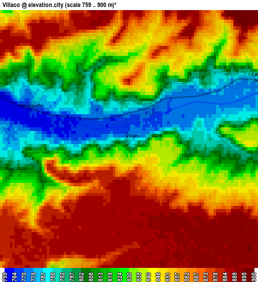
Below is the Elevation map of Villaco, which displays elevation range with different colors. Scale of the first map is from 759 to 900 m (2490 to 2953 ft) with average elevation of 839.9 meters (=2756 ft) [note 1]
These maps also provides idea of topography and contour of this city, they are displayed at different zoom levels. More info about maps, scale and edge coordinates you can find below images.
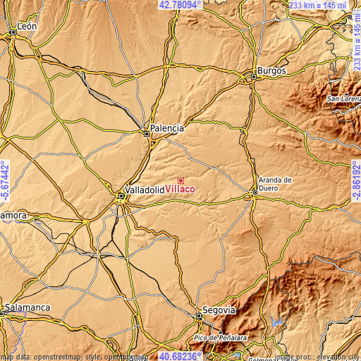
| \ | Map #1 | Topo.Map |
| Scale [m] | 759..900 m | × |
| Scale [ft] | 2490..2953 ft | × |
| Average | 839.9 m = 2756 ft | × |
| Width | 7.29 km = 4.5 mi | 233.3 km = 145 mi |
| Height | 7.29 km = 4.5 mi | 233.3 km = 145 mi |
| ↑Max Latitude | 41.773002° | 42.78094° |
| Latitude at center | 41.74022° | 41.74022° |
| ↓Min Latitude | 41.707421° | 40.68236° |
| ← Min Longitude | -4.312115° | -5.67442° |
| Longitude center | -4.26817° | -4.26817° |
| →Max Longitude | -4.224225° | -2.86192° |
Nearby cities:
Cities around Villaco sort by population:
• Valbuena de Duero elevation 735 m
11 km,  190°
190°
• Esguevillas de Esgueva 783 m
9.4 km,  276°
276°
• Castroverde de Cerrato 783 m
4.3 km,  65°
65°
• Fombellida 793 m
7.6 km, 66°
• Castrillo-Tejeriego 792 m
9.5 km,  244°
244°
• Vertavillo 817 m
11.4 km,  334°
334°
• Amusquillo 775 m
2.9 km,  288°
288°
• Villafuerte 823 m
4.6 km,  261°
261°
• Hérmedes de Cerrato 893 m
11.8 km,  41°
41°
• Canillas de Esgueva 815 m
12 km,  82°
82°
• Alba de Cerrato 776 m
11.4 km,  315°
315°
• Torre de Esgueva 815 m
6.5 km,  61°
61°
Multilingual:
 En español:
Villaco elevación 781 m.
 En France:
Villaco élévation 781 m.


Sources and notes:
- [note 1] Map square and city borders are not equal. Map elevation data is calculated only from area inside that square.
- [src 1] Elevation data from geonames database provided with same terms of usage.
- [src 2] The elevation map of Villaco is generated using elevation data from NASA's 3 arcsec (90m) resolution SRTM data.
- [src 3] Base (background) map © OpenStreetMap contributors tiles are generated by Geofabrik and OpenTopoMap.
Copyright & License:
This Villaco Elevation Map is licensed under CC BY-SA. You may reuse any part from this page, if you give a proper credit by linking to this URL:
 More info on terms of use page.