Villalbilla elevation
Villalbilla (Madrid, Provincia de Madrid), Spain elevation is 778 meters and Villalbilla elevation in feet is 2552 ft above sea level [src 1]. Villalbilla is a seat of a third-order administrative division (feature code) with elevation that is 175 meters (574 ft) bigger than average city elevation in Spain.
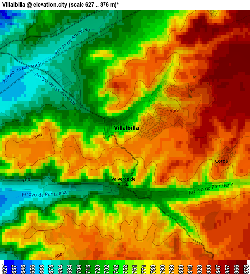
Below is the Elevation map of Villalbilla, which displays elevation range with different colors. Scale of the first map is from 627 to 876 m (2057 to 2874 ft) with average elevation of 771.7 meters (=2532 ft) [note 1]
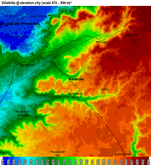
These maps also provides idea of topography and contour of this city, they are displayed at different zoom levels. More info about maps, scale and edge coordinates you can find below images.
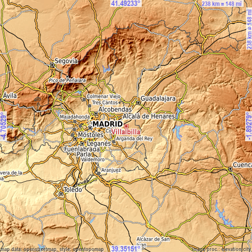
| \ | Map #1 | Map #2 | Topo.Map |
| Scale [m] | 627..876 m | 574..894 m | × |
| Scale [ft] | 2057..2874 ft | 1883..2933 ft | × |
| Average | 771.7 m = 2532 ft | 764.8 m = 2509 ft | × |
| Width | 7.44 km = 4.6 mi | 14.88 km = 9.2 mi | 238 km = 147.9 mi |
| Height | 7.44 km = 4.6 mi | 14.88 km = 9.2 mi | 238 km = 147.9 mi |
| ↑Max Latitude | 40.463883° | 40.497309° | 41.49233° |
| Latitude at center | 40.43044° | 40.43044° | 40.43044° |
| ↓Min Latitude | 40.396981° | 40.363505° | 39.35151° |
| ← Min Longitude | -3.342985° | -3.386931° | -4.70529° |
| Longitude center | -3.29904° | -3.29904° | -3.29904° |
| →Max Longitude | -3.255095° | -3.211149° | -1.89279° |
Nearby cities:
Cities around Villalbilla sort by population:
• Alcalá de Henares elevation 597 m
7.7 km,  318°
318°
• Torres de la Alameda 672 m
5.8 km,  238°
238°
• Nuevo Baztán 831 m
8.6 km,  145°
145°
• Loeches 646 m
11.1 km, 241°
• Los Santos de la Humosa 889 m
8.6 km,  26°
26°
• Pioz 865 m
11.3 km,  72°
72°
• Santorcaz 882 m
7.1 km,  49°
49°
• Corpa 814 m
3.4 km,  103°
103°
• Anchuelo 766 m
4.7 km, 33°
• Pezuela de las Torres 819 m
10.7 km, 98°
• Valverde de Alcalá 754 m
1.5 km,  171°
171°
• Pozuelo del Rey 808 m
7.5 km,  191°
191°
Multilingual:
 En español:
Villalbilla elevación 778 m.
 En France:
Villalbilla élévation 778 m.
 Auf Deutsch:
Villalbilla höhe über dem Meeresspiegel ist 778 m.

Sources and notes:
- [note 1] Map square and city borders are not equal. Map elevation data is calculated only from area inside that square.
- [src 1] Elevation data from geonames database provided with same terms of usage.
- [src 2] The elevation map of Villalbilla is generated using elevation data from NASA's 3 arcsec (90m) resolution SRTM data.
- [src 3] Base (background) map © OpenStreetMap contributors tiles are generated by Geofabrik and OpenTopoMap.
Copyright & License:
This Villalbilla Elevation Map is licensed under CC BY-SA. You may reuse any part from this page, if you give a proper credit by linking to this URL:
 More info on terms of use page.