Villameriel elevation
Villameriel (Castille and León, Provincia de Palencia), Spain elevation is 906 meters and Villameriel elevation in feet is 2972 ft above sea level [src 1]. Villameriel is a seat of a third-order administrative division (feature code) with elevation that is 303 meters (994 ft) bigger than average city elevation in Spain.
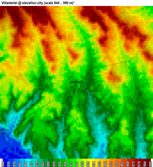
Below is the Elevation map of Villameriel, which displays elevation range with different colors. Scale of the first map is from 844 to 990 m (2769 to 3248 ft) with average elevation of 918 meters (=3012 ft) [note 1]
These maps also provides idea of topography and contour of this city, they are displayed at different zoom levels. More info about maps, scale and edge coordinates you can find below images.
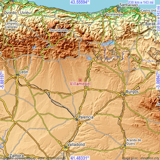
| \ | Map #1 | Topo.Map |
| Scale [m] | 844..990 m | × |
| Scale [ft] | 2769..3248 ft | × |
| Average | 918 m = 3012 ft | × |
| Width | 7.2 km = 4.5 mi | 230.5 km = 143.2 mi |
| Height | 7.2 km = 4.5 mi | 230.4 km = 143.2 mi |
| ↑Max Latitude | 42.560597° | 43.55594° |
| Latitude at center | 42.52822° | 42.52822° |
| ↓Min Latitude | 42.495826° | 41.48331° |
| ← Min Longitude | -4.519665° | -5.88197° |
| Longitude center | -4.47572° | -4.47572° |
| →Max Longitude | -4.431775° | -3.06947° |
Nearby cities:
Cities around Villameriel sort by population:
• Castrillo de Villavega elevation 849 m
8.2 km,  182°
182°
• Sotobañado y Priorato 896 m
7.4 km,  22°
22°
• Calahorra de Boedo 871 m
9 km,  55°
55°
• Páramo de Boedo 878 m
8.3 km,  47°
47°
• Villanuño de Valdavia 858 m
4.2 km,  237°
237°
• Villasila de Valdavia 868 m
6.8 km,  273°
273°
• Villaprovedo 875 m
6.6 km,  101°
101°
• Villaeles de Valdavia 886 m
9.7 km,  295°
295°
• Bárcena de Campos 843 m
5.2 km,  201°
201°
• Santa Cruz de Boedo 848 m
8.3 km,  92°
92°
• Olea de Boedo 933 m
9.3 km,  12°
12°
• San Cristóbal de Boedo 869 m
10.1 km,  81°
81°
Multilingual:
 En español:
Villameriel elevación 906 m.
 En France:
Villameriel élévation 906 m.
 Auf Deutsch:
Villameriel höhe über dem Meeresspiegel ist 906 m.

Sources and notes:
- [note 1] Map square and city borders are not equal. Map elevation data is calculated only from area inside that square.
- [src 1] Elevation data from geonames database provided with same terms of usage.
- [src 2] The elevation map of Villameriel is generated using elevation data from NASA's 3 arcsec (90m) resolution SRTM data.
- [src 3] Base (background) map © OpenStreetMap contributors tiles are generated by Geofabrik and OpenTopoMap.
Copyright & License:
This Villameriel Elevation Map is licensed under CC BY-SA. You may reuse any part from this page, if you give a proper credit by linking to this URL:
 More info on terms of use page.