Villardefrades elevation
Villardefrades (Castille and León, Provincia de Valladolid), Spain elevation is 725 meters and Villardefrades elevation in feet is 2379 ft above sea level [src 1]. Villardefrades is a seat of a third-order administrative division (feature code) with elevation that is 122 meters (400 ft) bigger than average city elevation in Spain.
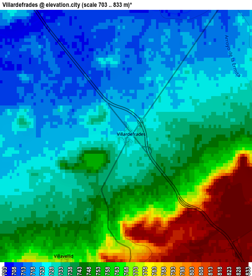
Below is the Elevation map of Villardefrades, which displays elevation range with different colors. Scale of the first map is from 703 to 833 m (2306 to 2733 ft) with average elevation of 741.1 meters (=2431 ft) [note 1]
These maps also provides idea of topography and contour of this city, they are displayed at different zoom levels. More info about maps, scale and edge coordinates you can find below images.
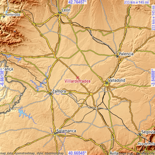
| \ | Map #1 | Topo.Map |
| Scale [m] | 703..833 m | × |
| Scale [ft] | 2306..2733 ft | × |
| Average | 741.1 m = 2431 ft | × |
| Width | 7.29 km = 4.5 mi | 233.4 km = 145 mi |
| Height | 7.29 km = 4.5 mi | 233.4 km = 145 mi |
| ↑Max Latitude | 41.756371° | 42.76457° |
| Latitude at center | 41.72358° | 41.72358° |
| ↓Min Latitude | 41.690772° | 40.66545° |
| ← Min Longitude | -5.299075° | -6.66138° |
| Longitude center | -5.25513° | -5.25513° |
| →Max Longitude | -5.211185° | -3.84888° |
Nearby cities:
Cities around Villardefrades sort by population:
• Vezdemarbán elevation 774 m
12 km,  230°
230°
• San Pedro de Latarce 709 m
6 km,  282°
282°
• Villagarcía de Campos 719 m
8.2 km,  39°
39°
• Mota del Marqués 748 m
12 km,  147°
147°
• Tiedra 824 m
8 km,  187°
187°
• Villanueva de los Caballeros 712 m
4 km,  8°
8°
• Urueña 832 m
4.3 km,  84°
84°
• San Cebrián de Mazote 761 m
10.1 km,  118°
118°
• Benafarces 738 m
11.8 km,  195°
195°
• Villavellid 766 m
3.9 km,  206°
206°
• Castromembibre 784 m
7 km,  215°
215°
• Pozuelo de la Orden 725 m
10.9 km,  358°
358°
Multilingual:
 En español:
Villardefrades elevación 725 m.
 En France:
Villardefrades élévation 725 m.
 Auf Deutsch:
Villardefrades höhe über dem Meeresspiegel ist 725 m.

Sources and notes:
- [note 1] Map square and city borders are not equal. Map elevation data is calculated only from area inside that square.
- [src 1] Elevation data from geonames database provided with same terms of usage.
- [src 2] The elevation map of Villardefrades is generated using elevation data from NASA's 3 arcsec (90m) resolution SRTM data.
- [src 3] Base (background) map © OpenStreetMap contributors tiles are generated by Geofabrik and OpenTopoMap.
Copyright & License:
This Villardefrades Elevation Map is licensed under CC BY-SA. You may reuse any part from this page, if you give a proper credit by linking to this URL:
 More info on terms of use page.