Villardondiego elevation
Villardondiego (Castille and León, Provincia de Zamora), Spain elevation is 737 meters and Villardondiego elevation in feet is 2418 ft above sea level [src 1]. Villardondiego is a seat of a third-order administrative division (feature code) with elevation that is 134 meters (440 ft) bigger than average city elevation in Spain.
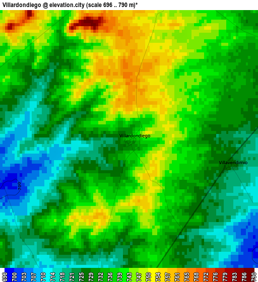
Below is the Elevation map of Villardondiego, which displays elevation range with different colors. Scale of the first map is from 696 to 790 m (2283 to 2592 ft) with average elevation of 733.8 meters (=2407 ft) [note 1]
These maps also provides idea of topography and contour of this city, they are displayed at different zoom levels. More info about maps, scale and edge coordinates you can find below images.
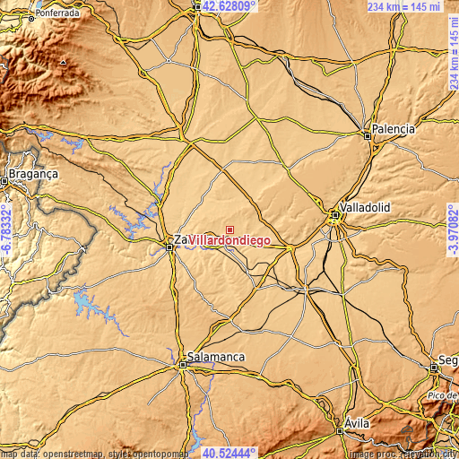
| \ | Map #1 | Topo.Map |
| Scale [m] | 696..790 m | × |
| Scale [ft] | 2283..2592 ft | × |
| Average | 733.8 m = 2407 ft | × |
| Width | 7.31 km = 4.5 mi | 233.9 km = 145.3 mi |
| Height | 7.31 km = 4.5 mi | 233.9 km = 145.3 mi |
| ↑Max Latitude | 41.617692° | 42.62809° |
| Latitude at center | 41.58483° | 41.58483° |
| ↓Min Latitude | 41.551952° | 40.52444° |
| ← Min Longitude | -5.421015° | -6.78332° |
| Longitude center | -5.37707° | -5.37707° |
| →Max Longitude | -5.333125° | -3.97082° |
Nearby cities:
Cities around Villardondiego sort by population:
• Toro elevation 733 m
6.9 km,  192°
192°
• Morales de Toro 703 m
7.9 km,  131°
131°
• Vezdemarbán 774 m
7.8 km,  6°
6°
• Pinilla de Toro 766 m
4.9 km, 12°
• Pozoantiguo 714 m
5.1 km,  285°
285°
• Villavendimio 728 m
2.9 km,  104°
104°
• Benafarces 738 m
8.1 km,  59°
59°
• Villalonso 723 m
6.8 km,  77°
77°
• Abezames 739 m
6.1 km,  318°
318°
• Fuentesecas 771 m
9.4 km,  302°
302°
• Castromembibre 784 m
11.4 km,  31°
31°
• Matilla la Seca 740 m
10.3 km,  266°
266°
Multilingual:
 En español:
Villardondiego elevación 737 m.
 En France:
Villardondiego élévation 737 m.
 Auf Deutsch:
Villardondiego höhe über dem Meeresspiegel ist 737 m.

Sources and notes:
- [note 1] Map square and city borders are not equal. Map elevation data is calculated only from area inside that square.
- [src 1] Elevation data from geonames database provided with same terms of usage.
- [src 2] The elevation map of Villardondiego is generated using elevation data from NASA's 3 arcsec (90m) resolution SRTM data.
- [src 3] Base (background) map © OpenStreetMap contributors tiles are generated by Geofabrik and OpenTopoMap.
Copyright & License:
This Villardondiego Elevation Map is licensed under CC BY-SA. You may reuse any part from this page, if you give a proper credit by linking to this URL:
 More info on terms of use page.