Villarramiel elevation
Villarramiel (Castille and León, Provincia de Palencia), Spain elevation is 766 meters and Villarramiel elevation in feet is 2513 ft above sea level [src 1]. Villarramiel is a seat of a third-order administrative division (feature code) with elevation that is 163 meters (535 ft) bigger than average city elevation in Spain.
Below is the Elevation map of Villarramiel, which displays elevation range with different colors. Scale of the first map is from 749 to 799 m (2457 to 2621 ft) with average elevation of 767.1 meters (=2517 ft) [note 1]
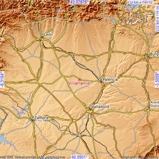
These maps also provides idea of topography and contour of this city, they are displayed at different zoom levels. More info about maps, scale and edge coordinates you can find below images.
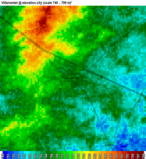
| \ | Map #1 | Topo.Map |
| Scale [m] | 749..799 m | × |
| Scale [ft] | 2457..2621 ft | × |
| Average | 767.1 m = 2517 ft | × |
| Width | 7.26 km = 4.5 mi | 232.2 km = 144.3 mi |
| Height | 7.26 km = 4.5 mi | 232.2 km = 144.3 mi |
| ↑Max Latitude | 42.075637° | 43.07876° |
| Latitude at center | 42.04301° | 42.04301° |
| ↓Min Latitude | 42.010366° | 40.9901° |
| ← Min Longitude | -4.956095° | -6.3184° |
| Longitude center | -4.91215° | -4.91215° |
| →Max Longitude | -4.868205° | -3.5059° |
Nearby cities:
Cities around Villarramiel sort by population:
• Castromocho elevation 756 m
7.4 km,  100°
100°
• Autillo de Campos 763 m
8.1 km,  52°
52°
• Herrín de Campos 775 m
9.7 km,  339°
339°
• Meneses de Campos 752 m
11.3 km,  182°
182°
• Villafrades de Campos 764 m
6.3 km,  308°
308°
• Capillas 761 m
3.7 km,  151°
151°
• Castil de Vela 761 m
7.6 km,  210°
210°
• Guaza de Campos 792 m
10.1 km,  1°
1°
• Villabaruz de Campos 752 m
7.8 km,  242°
242°
• Gatón de Campos 758 m
5.7 km,  277°
277°
• Baquerín de Campos 749 m
11.2 km,  105°
105°
• Boada de Campos 749 m
6.6 km, 154°
Multilingual:
 En español:
Villarramiel elevación 766 m.
 En France:
Villarramiel élévation 766 m.
 Auf Deutsch:
Villarramiel höhe über dem Meeresspiegel ist 766 m.

Sources and notes:
- [note 1] Map square and city borders are not equal. Map elevation data is calculated only from area inside that square.
- [src 1] Elevation data from geonames database provided with same terms of usage.
- [src 2] The elevation map of Villarramiel is generated using elevation data from NASA's 3 arcsec (90m) resolution SRTM data.
- [src 3] Base (background) map © OpenStreetMap contributors tiles are generated by Geofabrik and OpenTopoMap.
Copyright & License:
This Villarramiel Elevation Map is licensed under CC BY-SA. You may reuse any part from this page, if you give a proper credit by linking to this URL:
 More info on terms of use page.