Villatuelda elevation
Villatuelda (Castille and León, Provincia de Burgos), Spain elevation is 862 meters and Villatuelda elevation in feet is 2828 ft above sea level [src 1]. Villatuelda is a seat of a third-order administrative division (feature code) with elevation that is 259 meters (850 ft) bigger than average city elevation in Spain.
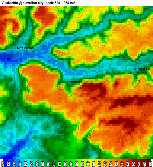
Below is the Elevation map of Villatuelda, which displays elevation range with different colors. Scale of the first map is from 828 to 958 m (2717 to 3143 ft) with average elevation of 892.8 meters (=2929 ft) [note 1]
These maps also provides idea of topography and contour of this city, they are displayed at different zoom levels. More info about maps, scale and edge coordinates you can find below images.
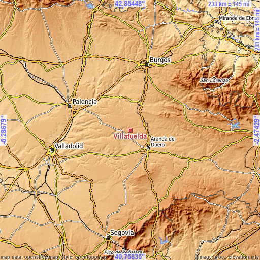
| \ | Map #1 | Topo.Map |
| Scale [m] | 828..958 m | × |
| Scale [ft] | 2717..3143 ft | × |
| Average | 892.8 m = 2929 ft | × |
| Width | 7.28 km = 4.5 mi | 233.1 km = 144.8 mi |
| Height | 7.28 km = 4.5 mi | 233.1 km = 144.8 mi |
| ↑Max Latitude | 41.847734° | 42.85448° |
| Latitude at center | 41.81499° | 41.81499° |
| ↓Min Latitude | 41.782229° | 40.75835° |
| ← Min Longitude | -3.924485° | -5.28679° |
| Longitude center | -3.88054° | -3.88054° |
| →Max Longitude | -3.836595° | -2.47429° |
Nearby cities:
Cities around Villatuelda sort by population:
• Roa elevation 819 m
13.7 km,  196°
196°
• Torresandino 855 m
2.9 km,  303°
303°
• Sotillo de la Ribera 845 m
6.2 km,  132°
132°
• Cilleruelo de Abajo 915 m
10.3 km,  41°
41°
• Villafruela 909 m
11.6 km,  346°
346°
• Cabañes de Esgueva 874 m
7.8 km,  77°
77°
• Berlangas de Roa 783 m
14 km,  177°
177°
• Olmedillo de Roa 842 m
5.7 km,  231°
231°
• Quintana del Pidio 845 m
12.4 km,  120°
120°
• Anguix 815 m
8 km,  211°
211°
• Terradillos de Esgueva 870 m
3.1 km, 82°
• Bahabón de Esgueva 918 m
13.5 km,  67°
67°
Multilingual:
 En español:
Villatuelda elevación 862 m.
 En France:
Villatuelda élévation 862 m.
 Auf Deutsch:
Villatuelda höhe über dem Meeresspiegel ist 862 m.

Sources and notes:
- [note 1] Map square and city borders are not equal. Map elevation data is calculated only from area inside that square.
- [src 1] Elevation data from geonames database provided with same terms of usage.
- [src 2] The elevation map of Villatuelda is generated using elevation data from NASA's 3 arcsec (90m) resolution SRTM data.
- [src 3] Base (background) map © OpenStreetMap contributors tiles are generated by Geofabrik and OpenTopoMap.
Copyright & License:
This Villatuelda Elevation Map is licensed under CC BY-SA. You may reuse any part from this page, if you give a proper credit by linking to this URL:
 More info on terms of use page.