Villaturde elevation
Villaturde (Castille and León, Provincia de Palencia), Spain elevation is 844 meters and Villaturde elevation in feet is 2769 ft above sea level [src 1]. Villaturde is a seat of a third-order administrative division (feature code) with elevation that is 241 meters (791 ft) bigger than average city elevation in Spain.
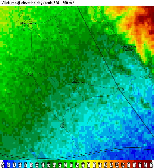
Below is the Elevation map of Villaturde, which displays elevation range with different colors. Scale of the first map is from 824 to 890 m (2703 to 2920 ft) with average elevation of 845.3 meters (=2773 ft) [note 1]
These maps also provides idea of topography and contour of this city, they are displayed at different zoom levels. More info about maps, scale and edge coordinates you can find below images.
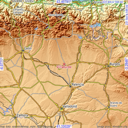
| \ | Map #1 | Topo.Map |
| Scale [m] | 824..890 m | × |
| Scale [ft] | 2703..2920 ft | × |
| Average | 845.3 m = 2773 ft | × |
| Width | 7.22 km = 4.5 mi | 231 km = 143.5 mi |
| Height | 7.22 km = 4.5 mi | 231 km = 143.5 mi |
| ↑Max Latitude | 42.410145° | 43.40791° |
| Latitude at center | 42.37769° | 42.37769° |
| ↓Min Latitude | 42.345218° | 41.33029° |
| ← Min Longitude | -4.714795° | -6.0771° |
| Longitude center | -4.67085° | -4.67085° |
| →Max Longitude | -4.626905° | -3.2646° |
Nearby cities:
Cities around Villaturde sort by population:
• Carrión de los Condes elevation 837 m
7 km,  125°
125°
• Calzada de los Molinos 828 m
5.8 km,  165°
165°
• Bustillo de la Vega 885 m
10.5 km,  326°
326°
• Villamoronta 857 m
3.7 km,  321°
321°
• Renedo de la Vega 875 m
8.8 km,  342°
342°
• Villarrabé 903 m
10.5 km,  297°
297°
• Quintanilla de Onsoña 888 m
10.2 km,  3°
3°
• Villalcázar de Sirga 807 m
12.5 km,  122°
122°
• San Mamés de Campos 821 m
9 km,  106°
106°
• Riberos de la Cueza 828 m
11.9 km,  202°
202°
• Bustillo del Páramo de Carrión 857 m
6.2 km,  246°
246°
• Nogal de las Huertas 847 m
2.9 km,  55°
55°
Multilingual:
 En español:
Villaturde elevación 844 m.
 En France:
Villaturde élévation 844 m.
 Auf Deutsch:
Villaturde höhe über dem Meeresspiegel ist 844 m.

Sources and notes:
- [note 1] Map square and city borders are not equal. Map elevation data is calculated only from area inside that square.
- [src 1] Elevation data from geonames database provided with same terms of usage.
- [src 2] The elevation map of Villaturde is generated using elevation data from NASA's 3 arcsec (90m) resolution SRTM data.
- [src 3] Base (background) map © OpenStreetMap contributors tiles are generated by Geofabrik and OpenTopoMap.
Copyright & License:
This Villaturde Elevation Map is licensed under CC BY-SA. You may reuse any part from this page, if you give a proper credit by linking to this URL:
 More info on terms of use page.