Villoruebo elevation
Villoruebo (Castille and León, Provincia de Burgos), Spain elevation is 1122 meters and Villoruebo elevation in feet is 3681 ft above sea level [src 1]. Villoruebo is a seat of a third-order administrative division (feature code) with elevation that is 519 meters (1703 ft) bigger than average city elevation in Spain.
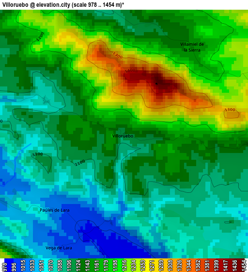
Below is the Elevation map of Villoruebo, which displays elevation range with different colors. Scale of the first map is from 978 to 1454 m (3209 to 4770 ft) with average elevation of 1138.7 meters (=3736 ft) [note 1]
These maps also provides idea of topography and contour of this city, they are displayed at different zoom levels. More info about maps, scale and edge coordinates you can find below images.
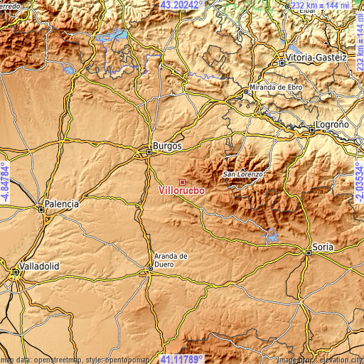
| \ | Map #1 | Topo.Map |
| Scale [m] | 978..1454 m | × |
| Scale [ft] | 3209..4770 ft | × |
| Average | 1138.7 m = 3736 ft | × |
| Width | 7.24 km = 4.5 mi | 231.8 km = 144 mi |
| Height | 7.24 km = 4.5 mi | 231.8 km = 144 mi |
| ↑Max Latitude | 42.201303° | 43.20242° |
| Latitude at center | 42.16874° | 42.16874° |
| ↓Min Latitude | 42.136161° | 41.11789° |
| ← Min Longitude | -3.485535° | -4.84784° |
| Longitude center | -3.44159° | -3.44159° |
| →Max Longitude | -3.397645° | -2.03534° |
Nearby cities:
Cities around Villoruebo sort by population:
• Revilla del Campo elevation 942 m
9.6 km,  299°
299°
• Hortigüela 940 m
11.2 km,  173°
173°
• Campolara 973 m
5.6 km, 167°
• San Millán de Lara 1083 m
8.7 km,  114°
114°
• Palazuelos de la Sierra 1106 m
5 km,  342°
342°
• Mambrillas de Lara 992 m
8.4 km,  191°
191°
• Cuevas de San Clemente 1033 m
11.3 km,  247°
247°
• San Adrián de Juarros 1046 m
12.1 km,  346°
346°
• Villamiel de la Sierra 1150 m
3.2 km,  38°
38°
• Torrelara 998 m
6.2 km,  267°
267°
• Villaespasa 962 m
8.2 km,  158°
158°
• Jaramillo Quemado 988 m
11.5 km,  143°
143°
Multilingual:
 En español:
Villoruebo elevación 1122 m.
 En France:
Villoruebo élévation 1122 m.
 Auf Deutsch:
Villoruebo höhe über dem Meeresspiegel ist 1122 m.

Sources and notes:
- [note 1] Map square and city borders are not equal. Map elevation data is calculated only from area inside that square.
- [src 1] Elevation data from geonames database provided with same terms of usage.
- [src 2] The elevation map of Villoruebo is generated using elevation data from NASA's 3 arcsec (90m) resolution SRTM data.
- [src 3] Base (background) map © OpenStreetMap contributors tiles are generated by Geofabrik and OpenTopoMap.
Copyright & License:
This Villoruebo Elevation Map is licensed under CC BY-SA. You may reuse any part from this page, if you give a proper credit by linking to this URL:
 More info on terms of use page.