Vita elevation
Vita (Castille and León, Provincia de Ávila), Spain elevation is 997 meters and Vita elevation in feet is 3271 ft above sea level [src 1]. Vita is a seat of a third-order administrative division (feature code) with elevation that is 394 meters (1293 ft) bigger than average city elevation in Spain.
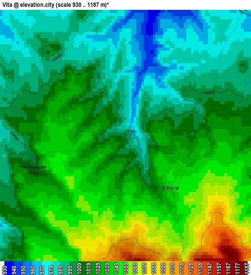
Below is the Elevation map of Vita, which displays elevation range with different colors. Scale of the first map is from 930 to 1187 m (3051 to 3894 ft) with average elevation of 1021.1 meters (=3350 ft) [note 1]
These maps also provides idea of topography and contour of this city, they are displayed at different zoom levels. More info about maps, scale and edge coordinates you can find below images.
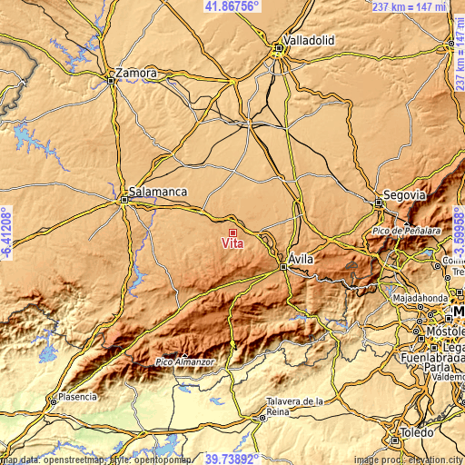
| \ | Map #1 | Topo.Map |
| Scale [m] | 930..1187 m | × |
| Scale [ft] | 3051..3894 ft | × |
| Average | 1021.1 m = 3350 ft | × |
| Width | 7.4 km = 4.6 mi | 236.7 km = 147.1 mi |
| Height | 7.4 km = 4.6 mi | 236.7 km = 147.1 mi |
| ↑Max Latitude | 40.845032° | 41.86756° |
| Latitude at center | 40.81178° | 40.81178° |
| ↓Min Latitude | 40.778511° | 39.73892° |
| ← Min Longitude | -5.049775° | -6.41208° |
| Longitude center | -5.00583° | -5.00583° |
| →Max Longitude | -4.961885° | -3.59958° |
Nearby cities:
Cities around Vita sort by population:
• Crespos elevation 927 m
7.2 km,  23°
23°
• Blascomillán 949 m
6.9 km,  260°
260°
• Collado de Contreras 917 m
10.5 km,  36°
36°
• Narros del Castillo 952 m
6.9 km,  318°
318°
• Herreros de Suso 1011 m
2.9 km,  251°
251°
• San García de Ingelmos 1069 m
10.4 km,  242°
242°
• Santo Tomé de Zabarcos 959 m
8.5 km,  108°
108°
• Muñogrande 944 m
7.1 km,  80°
80°
• Viñegra de Moraña 910 m
8.3 km,  58°
58°
• Sigeres 966 m
6.2 km,  102°
102°
• Brabos 983 m
6.7 km,  123°
123°
• Rivilla de Barajas 900 m
10.1 km,  8°
8°
Multilingual:
 En español:
Vita elevación 997 m.
 En France:
Vita élévation 997 m.


Sources and notes:
- [note 1] Map square and city borders are not equal. Map elevation data is calculated only from area inside that square.
- [src 1] Elevation data from geonames database provided with same terms of usage.
- [src 2] The elevation map of Vita is generated using elevation data from NASA's 3 arcsec (90m) resolution SRTM data.
- [src 3] Base (background) map © OpenStreetMap contributors tiles are generated by Geofabrik and OpenTopoMap.
Copyright & License:
This Vita Elevation Map is licensed under CC BY-SA. You may reuse any part from this page, if you give a proper credit by linking to this URL:
 More info on terms of use page.