Yebes elevation
Yebes (Castille-La Mancha, Provincia de Guadalajara), Spain elevation is 913 meters and Yebes elevation in feet is 2995 ft above sea level [src 1]. Yebes is a seat of a third-order administrative division (feature code) with elevation that is 310 meters (1017 ft) bigger than average city elevation in Spain.
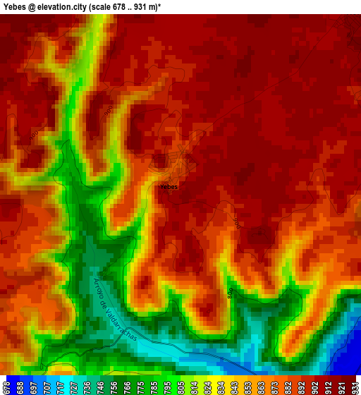
Below is the Elevation map of Yebes, which displays elevation range with different colors. Scale of the first map is from 678 to 931 m (2224 to 3054 ft) with average elevation of 861.2 meters (=2825 ft) [note 1]
These maps also provides idea of topography and contour of this city, they are displayed at different zoom levels. More info about maps, scale and edge coordinates you can find below images.
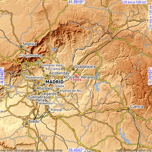
| \ | Map #1 | Topo.Map |
| Scale [m] | 678..931 m | × |
| Scale [ft] | 2224..3054 ft | × |
| Average | 861.2 m = 2825 ft | × |
| Width | 7.43 km = 4.6 mi | 237.7 km = 147.7 mi |
| Height | 7.43 km = 4.6 mi | 237.7 km = 147.7 mi |
| ↑Max Latitude | 40.565012° | 41.5919° |
| Latitude at center | 40.53162° | 40.53162° |
| ↓Min Latitude | 40.498211° | 39.4543° |
| ← Min Longitude | -3.151765° | -4.51407° |
| Longitude center | -3.10782° | -3.10782° |
| →Max Longitude | -3.063875° | -1.70157° |
Nearby cities:
Cities around Yebes sort by population:
• Horche elevation 864 m
5.3 km,  47°
47°
• Chiloeches 857 m
6.2 km,  314°
314°
• Pioz 865 m
9.5 km,  214°
214°
• Pozo de Guadalajara 890 m
7.4 km,  237°
237°
• Loranca de Tajuña 697 m
9.8 km,  181°
181°
• Aranzueque 681 m
5.3 km,  148°
148°
• Hontoba 761 m
10.4 km, 145°
• Lupiana 760 m
9.8 km,  29°
29°
• Armuña de Tajuña 704 m
6.7 km,  92°
92°
• Renera 766 m
9.2 km,  120°
120°
• Fuentelviejo 901 m
10.5 km, 93°
• Valdarachas 760 m
2.3 km,  224°
224°
Multilingual:
 En español:
Yebes elevación 913 m.
 En France:
Yebes élévation 913 m.


Sources and notes:
- [note 1] Map square and city borders are not equal. Map elevation data is calculated only from area inside that square.
- [src 1] Elevation data from geonames database provided with same terms of usage.
- [src 2] The elevation map of Yebes is generated using elevation data from NASA's 3 arcsec (90m) resolution SRTM data.
- [src 3] Base (background) map © OpenStreetMap contributors tiles are generated by Geofabrik and OpenTopoMap.
Copyright & License:
This Yebes Elevation Map is licensed under CC BY-SA. You may reuse any part from this page, if you give a proper credit by linking to this URL:
 More info on terms of use page.