Zamora elevation
Zamora (Castille and León, Provincia de Zamora), Spain elevation is 662 meters and Zamora elevation in feet is 2172 ft above sea level [src 1]. Zamora is a seat of a second-order administrative division (feature code) with elevation that is 59 meters (194 ft) bigger than average city elevation in Spain.
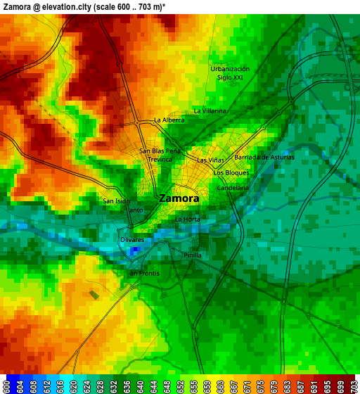
Below is the Elevation map of Zamora, which displays elevation range with different colors. Scale of the first map is from 600 to 703 m (1969 to 2306 ft) with average elevation of 650.2 meters (=2133 ft) [note 1]
These maps also provides idea of topography and contour of this city, they are displayed at different zoom levels. More info about maps, scale and edge coordinates you can find below images.
| \ | Map #1 | Map #2 | Topo.Map |
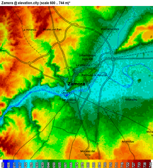
| Scale [m] | 600..703 m | 600..744 m | × |
| Scale [ft] | 1969..2306 ft | 1969..2441 ft | × |
| Average | 650.2 m = 2133 ft | 668 m = 2192 ft | × |
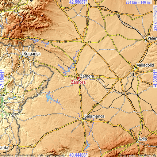
| Width | 7.32 km = 4.5 mi | 14.64 km = 9.1 mi | 234.2 km = 145.5 mi |
| Height | 7.32 km = 4.5 mi | 14.64 km = 9.1 mi | 234.2 km = 145.5 mi |
| ↑Max Latitude | 41.539232° | 41.572116° | 42.55087° |
| Latitude at center | 41.50633° | 41.50633° | 41.50633° |
| ↓Min Latitude | 41.473412° | 41.440477° | 40.44466° |
| ← Min Longitude | -5.788505° | -5.832451° | -7.15081° |
| Longitude center | -5.74456° | -5.74456° | -5.74456° |
| →Max Longitude | -5.700615° | -5.656669° | -4.33831° |
Nearby cities:
Cities around Zamora sort by population:
• Morales del Vino elevation 698 m
6.7 km,  170°
170°
• Villaralbo 641 m
5.3 km,  107°
107°
• Moraleja del Vino 687 m
8.7 km,  122°
122°
• Monfarracinos 643 m
6.2 km,  29°
29°
• Cubillos 670 m
7.6 km,  3°
3°
• Casaseca de las Chanas 710 m
9.5 km,  142°
142°
• Valcabado 682 m
4.7 km,  355°
355°
• Arcenillas 701 m
7.4 km, 138°
• Molacillos 642 m
11 km,  39°
39°
• Entrala 704 m
8.5 km,  186°
186°
• Cazurra 727 m
10.6 km,  161°
161°
• Roales 700 m
5.5 km,  335°
335°
Multilingual:
 En español:
Zamora elevación 662 m.
 En France:
Zamora élévation 662 m.


Sources and notes:
- [note 1] Map square and city borders are not equal. Map elevation data is calculated only from area inside that square.
- [src 1] Elevation data from geonames database provided with same terms of usage.
- [src 2] The elevation map of Zamora is generated using elevation data from NASA's 3 arcsec (90m) resolution SRTM data.
- [src 3] Base (background) map © OpenStreetMap contributors tiles are generated by Geofabrik and OpenTopoMap.
Copyright & License:
This Zamora Elevation Map is licensed under CC BY-SA. You may reuse any part from this page, if you give a proper credit by linking to this URL:
 More info on terms of use page.