Zarautz elevation
Zarautz (Basque Country, Gipuzkoa), Spain elevation is 6 meters and Zarautz elevation in feet is 20 ft above sea level [src 1]. Zarautz is a seat of a third-order administrative division (feature code) with elevation that is 597 meters (1959 ft) smaller than average city elevation in Spain.
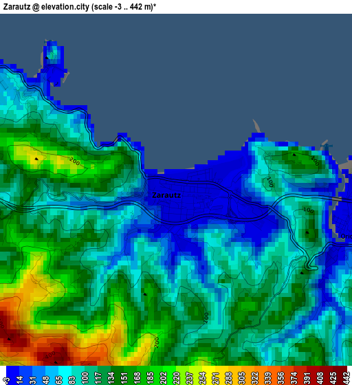
Below is the Elevation map of Zarautz, which displays elevation range with different colors. Scale of the first map is from -3 to 442 m (-10 to 1450 ft) with average elevation of 115 meters (=377 ft) [note 1]
These maps also provides idea of topography and contour of this city, they are displayed at different zoom levels. More info about maps, scale and edge coordinates you can find below images.
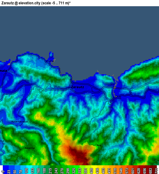
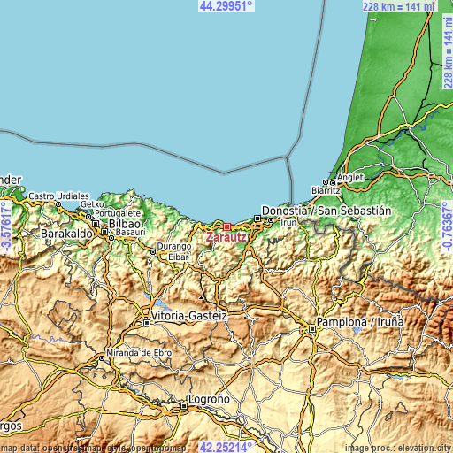
| \ | Map #1 | Map #2 | Topo.Map |
| Scale [m] | -3..442 m | -5..711 m | × |
| Scale [ft] | -10..1450 ft | -16..2333 ft | × |
| Average | 115 m = 377 ft | 175.3 m = 575 ft | × |
| Width | 7.11 km = 4.4 mi | 14.23 km = 8.8 mi | 227.6 km = 141.4 mi |
| Height | 7.11 km = 4.4 mi | 14.23 km = 8.8 mi | 227.6 km = 141.4 mi |
| ↑Max Latitude | 43.316422° | 43.348387° | 44.29951° |
| Latitude at center | 43.28444° | 43.28444° | 43.28444° |
| ↓Min Latitude | 43.252441° | 43.220426° | 42.25214° |
| ← Min Longitude | -2.213865° | -2.257811° | -3.57617° |
| Longitude center | -2.16992° | -2.16992° | -2.16992° |
| →Max Longitude | -2.125975° | -2.082029° | -0.76367° |
Nearby cities:
Cities around Zarautz sort by population:
• Oria elevation 40 m
12.7 km,  104°
104°
• Lasarte 16 m
12.1 km, 98°
• Zumaia 2 m
6.9 km,  279°
279°
• Usurbil 33 m
9.9 km, 98°
• Orio 43 m
3.7 km, 100°
• Getaria 32 m
3.5 km,  306°
306°
• Asteasu 104 m
11.6 km,  149°
149°
• Aizarnazabal 58 m
6.2 km,  239°
239°
• Larraul 234 m
12.1 km, 152°
• Zizurkil 115 m
12.2 km,  140°
140°
• Zestoa 74 m
8.7 km, 235°
• Aia 297 m
5.5 km,  161°
161°
Multilingual:
 En español:
Zarauz elevación 6 m.
 En France:
Zarautz élévation 6 m.


Sources and notes:
- [note 1] Map square and city borders are not equal. Map elevation data is calculated only from area inside that square.
- [src 1] Elevation data from geonames database provided with same terms of usage.
- [src 2] The elevation map of Zarautz is generated using elevation data from NASA's 3 arcsec (90m) resolution SRTM data.
- [src 3] Base (background) map © OpenStreetMap contributors tiles are generated by Geofabrik and OpenTopoMap.
Copyright & License:
This Zarautz Elevation Map is licensed under CC BY-SA. You may reuse any part from this page, if you give a proper credit by linking to this URL:
 More info on terms of use page.