Alfondeguilla elevation
Alfondeguilla (Valencia, Província de Castelló), Spain elevation is 281 meters and Alfondeguilla elevation in feet is 922 ft above sea level [src 1]. Alfondeguilla is a seat of a third-order administrative division (feature code) with elevation that is 322 meters (1056 ft) smaller than average city elevation in Spain.
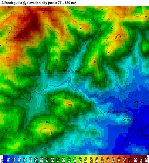
Below is the Elevation map of Alfondeguilla, which displays elevation range with different colors. Scale of the first map is from 77 to 860 m (253 to 2822 ft) with average elevation of 362 meters (=1188 ft) [note 1]
These maps also provides idea of topography and contour of this city, they are displayed at different zoom levels. More info about maps, scale and edge coordinates you can find below images.
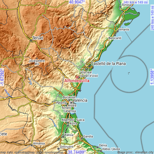
| \ | Map #1 | Topo.Map |
| Scale [m] | 77..860 m | × |
| Scale [ft] | 253..2822 ft | × |
| Average | 362 m = 1188 ft | × |
| Width | 7.5 km = 4.7 mi | 240.1 km = 149.2 mi |
| Height | 7.5 km = 4.7 mi | 240.1 km = 149.2 mi |
| ↑Max Latitude | 39.867068° | 40.9047° |
| Latitude at center | 39.83333° | 39.83333° |
| ↓Min Latitude | 39.799576° | 38.74499° |
| ← Min Longitude | -0.310615° | -1.67292° |
| Longitude center | -0.26667° | -0.26667° |
| →Max Longitude | -0.222725° | 1.13958° |
Nearby cities:
Cities around Alfondeguilla sort by population:
• Nules elevation 21 m
9.7 km,  76°
76°
• Almenara 7 m
10.2 km,  155°
155°
• Moncofa 9 m
10.6 km,  104°
104°
• Villavieja 33 m
7.4 km, 75°
• Chilches 12 m
8.8 km,  129°
129°
• Artana 259 m
6.5 km,  6°
6°
• Quartell 46 m
10.7 km,  179°
179°
• Quart de les Valls 38 m
11.1 km, 180°
• Eslida 338 m
6.2 km,  332°
332°
• Alfara de Algimia 182 m
10.3 km,  223°
223°
• Azuébar 295 m
8.5 km,  270°
270°
• Chóvar 417 m
4.7 km,  293°
293°
Multilingual:
 En español:
Alfondeguilla elevación 281 m.
 En France:
Alfondeguilla élévation 281 m.
 Auf Deutsch:
Alfondeguilla höhe über dem Meeresspiegel ist 281 m.

Sources and notes:
- [note 1] Map square and city borders are not equal. Map elevation data is calculated only from area inside that square.
- [src 1] Elevation data from geonames database provided with same terms of usage.
- [src 2] The elevation map of Alfondeguilla is generated using elevation data from NASA's 3 arcsec (90m) resolution SRTM data.
- [src 3] Base (background) map © OpenStreetMap contributors tiles are generated by Geofabrik and OpenTopoMap.
Copyright & License:
This Alfondeguilla Elevation Map is licensed under CC BY-SA. You may reuse any part from this page, if you give a proper credit by linking to this URL:
 More info on terms of use page.