Alpuente elevation
Alpuente (Valencia, Província de València), Spain elevation is 844 meters and Alpuente elevation in feet is 2769 ft above sea level [src 1]. Alpuente is a seat of a third-order administrative division (feature code) with elevation that is 241 meters (791 ft) bigger than average city elevation in Spain.
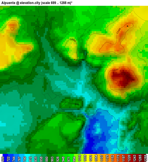
Below is the Elevation map of Alpuente, which displays elevation range with different colors. Scale of the first map is from 699 to 1288 m (2293 to 4226 ft) with average elevation of 925.3 meters (=3036 ft) [note 1]
These maps also provides idea of topography and contour of this city, they are displayed at different zoom levels. More info about maps, scale and edge coordinates you can find below images.
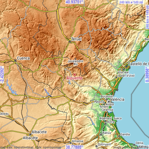
| \ | Map #1 | Topo.Map |
| Scale [m] | 699..1288 m | × |
| Scale [ft] | 2293..4226 ft | × |
| Average | 925.3 m = 3036 ft | × |
| Width | 7.5 km = 4.7 mi | 240 km = 149.1 mi |
| Height | 7.5 km = 4.7 mi | 240 km = 149.1 mi |
| ↑Max Latitude | 39.900391° | 40.93751° |
| Latitude at center | 39.86667° | 39.86667° |
| ↓Min Latitude | 39.832932° | 38.77885° |
| ← Min Longitude | -1.060615° | -2.42292° |
| Longitude center | -1.01667° | -1.01667° |
| →Max Longitude | -0.972725° | 0.38958° |
Nearby cities:
Cities around Alpuente sort by population:
• Chelva elevation 483 m
13.2 km,  172°
172°
• Tuéjar 681 m
11.2 km,  187°
187°
• Loriguilla 525 m
22.1 km,  157°
157°
• Titaguas 838 m
5.7 km,  270°
270°
• Higueruelas 778 m
17 km,  123°
123°
• Andilla 1046 m
18.9 km,  101°
101°
• Calles 378 m
16.6 km, 166°
• La Yesa 1003 m
6 km,  71°
71°
• Benagéber 751 m
18.1 km,  203°
203°
• Graja de Campalbo 1124 m
21.6 km,  279°
279°
• Arcos de las Salinas 1324 m
13 km,  353°
353°
• Torrijas 1381 m
17.6 km,  18°
18°
Multilingual:
 En español:
Alpuente elevación 844 m.
 En France:
Alpuente élévation 844 m.
 Auf Deutsch:
Alpuente höhe über dem Meeresspiegel ist 844 m.

Sources and notes:
- [note 1] Map square and city borders are not equal. Map elevation data is calculated only from area inside that square.
- [src 1] Elevation data from geonames database provided with same terms of usage.
- [src 2] The elevation map of Alpuente is generated using elevation data from NASA's 3 arcsec (90m) resolution SRTM data.
- [src 3] Base (background) map © OpenStreetMap contributors tiles are generated by Geofabrik and OpenTopoMap.
Copyright & License:
This Alpuente Elevation Map is licensed under CC BY-SA. You may reuse any part from this page, if you give a proper credit by linking to this URL:
 More info on terms of use page.