Altarejos elevation
Altarejos (Castille-La Mancha, Provincia de Cuenca), Spain elevation is 883 meters and Altarejos elevation in feet is 2897 ft above sea level [src 1]. Altarejos is a seat of a third-order administrative division (feature code) with elevation that is 280 meters (919 ft) bigger than average city elevation in Spain.
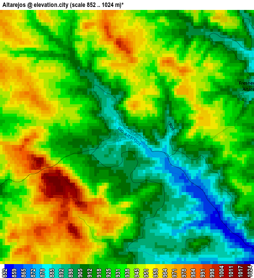
Below is the Elevation map of Altarejos, which displays elevation range with different colors. Scale of the first map is from 852 to 1024 m (2795 to 3360 ft) with average elevation of 930.3 meters (=3052 ft) [note 1]
These maps also provides idea of topography and contour of this city, they are displayed at different zoom levels. More info about maps, scale and edge coordinates you can find below images.
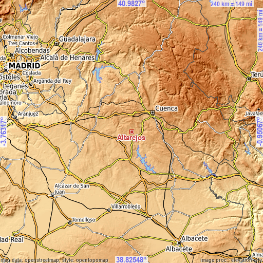
| \ | Map #1 | Topo.Map |
| Scale [m] | 852..1024 m | × |
| Scale [ft] | 2795..3360 ft | × |
| Average | 930.3 m = 3052 ft | × |
| Width | 7.5 km = 4.7 mi | 239.9 km = 149.1 mi |
| Height | 7.5 km = 4.7 mi | 239.9 km = 149.1 mi |
| ↑Max Latitude | 39.946279° | 40.9827° |
| Latitude at center | 39.91258° | 39.91258° |
| ↓Min Latitude | 39.878865° | 38.82548° |
| ← Min Longitude | -2.400865° | -3.76317° |
| Longitude center | -2.35692° | -2.35692° |
| →Max Longitude | -2.312975° | -0.95067° |
Nearby cities:
Cities around Altarejos sort by population:
• San Lorenzo de la Parrilla elevation 950 m
6.8 km,  182°
182°
• Villares del Saz 873 m
14.9 km,  237°
237°
• Villarejo-Periesteban 920 m
8.5 km, 238°
• Olivares de Júcar 921 m
16.9 km, 179°
• Villaverde y Pasaconsol 861 m
17.6 km,  153°
153°
• Albaladejo del Cuende 882 m
16 km,  137°
137°
• Cervera del Llano 899 m
15.4 km,  200°
200°
• Belmontejo 860 m
10.1 km,  174°
174°
• Zafra de Záncara 922 m
17.3 km,  262°
262°
• Huerta de la Obispalía 910 m
13.4 km,  309°
309°
• Fresneda de Altarejos 905 m
3.9 km,  67°
67°
• Mota de Altarejos 860 m
5.3 km,  130°
130°
Multilingual:
 En español:
Altarejos elevación 883 m.
 En France:
Altarejos élévation 883 m.
 Auf Deutsch:
Altarejos höhe über dem Meeresspiegel ist 883 m.

Sources and notes:
- [note 1] Map square and city borders are not equal. Map elevation data is calculated only from area inside that square.
- [src 1] Elevation data from geonames database provided with same terms of usage.
- [src 2] The elevation map of Altarejos is generated using elevation data from NASA's 3 arcsec (90m) resolution SRTM data.
- [src 3] Base (background) map © OpenStreetMap contributors tiles are generated by Geofabrik and OpenTopoMap.
Copyright & License:
This Altarejos Elevation Map is licensed under CC BY-SA. You may reuse any part from this page, if you give a proper credit by linking to this URL:
 More info on terms of use page.