Antigua elevation
Antigua (Canary Islands, Provincia de Las Palmas), Spain elevation is 263 meters and Antigua elevation in feet is 863 ft above sea level [src 1]. Antigua is a seat of a third-order administrative division (feature code) with elevation that is 340 meters (1115 ft) smaller than average city elevation in Spain.
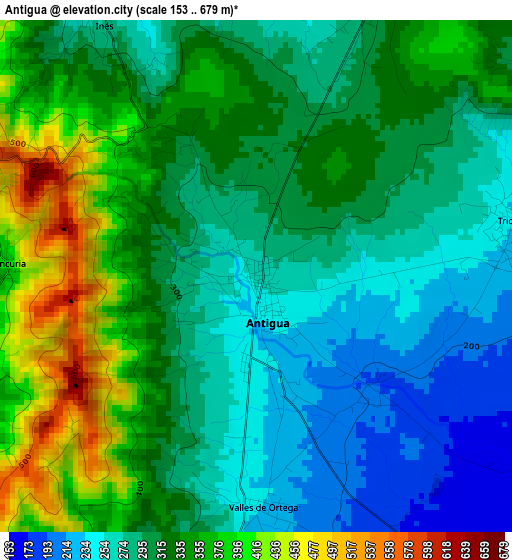
Below is the Elevation map of Antigua, which displays elevation range with different colors. Scale of the first map is from 153 to 679 m (502 to 2228 ft) with average elevation of 314.9 meters (=1033 ft) [note 1]
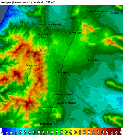
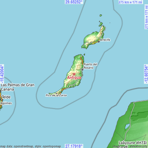
These maps also provides idea of topography and contour of this city, they are displayed at different zoom levels. More info about maps, scale and edge coordinates you can find below images.
| \ | Map #1 | Map #2 | Topo.Map |
| Scale [m] | 153..679 m | -4..712 m | × |
| Scale [ft] | 502..2228 ft | -13..2336 ft | × |
| Average | 314.9 m = 1033 ft | 282.2 m = 926 ft | × |
| Width | 8.59 km = 5.3 mi | 17.19 km = 10.7 mi | 275 km = 170.9 mi |
| Height | 8.59 km = 5.3 mi | 17.19 km = 10.7 mi | 275 km = 170.9 mi |
| ↑Max Latitude | 28.461711° | 28.500338° | 29.65252° |
| Latitude at center | 28.42307° | 28.42307° | 28.42307° |
| ↓Min Latitude | 28.384415° | 28.345746° | 27.17918° |
| ← Min Longitude | -14.057735° | -14.101681° | -15.42004° |
| Longitude center | -14.01379° | -14.01379° | -14.01379° |
| →Max Longitude | -13.969845° | -13.925899° | -12.60754° |
Nearby cities:
Cities around Antigua sort by population:
• Puerto del Rosario elevation 43 m
17.1 km,  59°
59°
• Puerto del Carmen 44 m
65.1 km,  31°
31°
• La Oliva 225 m
22.4 km,  21°
21°
• Pájara 213 m
12.2 km,  228°
228°
• Tías 177 m
69.8 km, 31°
• Tuineje 185 m
11.5 km,  196°
196°
• Corralejo 14 m
37.1 km, 22°
• Playa Blanca 16 m
52.3 km, 20°
• Yaiza 168 m
64.1 km, 22°
• Costa Calma 26 m
35.8 km,  215°
215°
• El Cotillo 20 m
28.9 km,  1°
1°
• Mácher 198 m
66.3 km, 28°
Multilingual:
 En español:
Antigua elevación 263 m.
 En France:
Antigua élévation 263 m.


Sources and notes:
- [note 1] Map square and city borders are not equal. Map elevation data is calculated only from area inside that square.
- [src 1] Elevation data from geonames database provided with same terms of usage.
- [src 2] The elevation map of Antigua is generated using elevation data from NASA's 3 arcsec (90m) resolution SRTM data.
- [src 3] Base (background) map © OpenStreetMap contributors tiles are generated by Geofabrik and OpenTopoMap.
Copyright & License:
This Antigua Elevation Map is licensed under CC BY-SA. You may reuse any part from this page, if you give a proper credit by linking to this URL:
 More info on terms of use page.