Balones elevation
Balones (Valencia, Provincia de Alicante), Spain elevation is 693 meters and Balones elevation in feet is 2274 ft above sea level [src 1]. Balones is a seat of a third-order administrative division (feature code) with elevation that is 90 meters (295 ft) bigger than average city elevation in Spain.
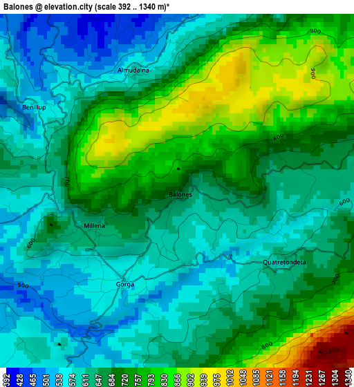
Below is the Elevation map of Balones, which displays elevation range with different colors. Scale of the first map is from 392 to 1340 m (1286 to 4396 ft) with average elevation of 676.9 meters (=2221 ft) [note 1]
These maps also provides idea of topography and contour of this city, they are displayed at different zoom levels. More info about maps, scale and edge coordinates you can find below images.
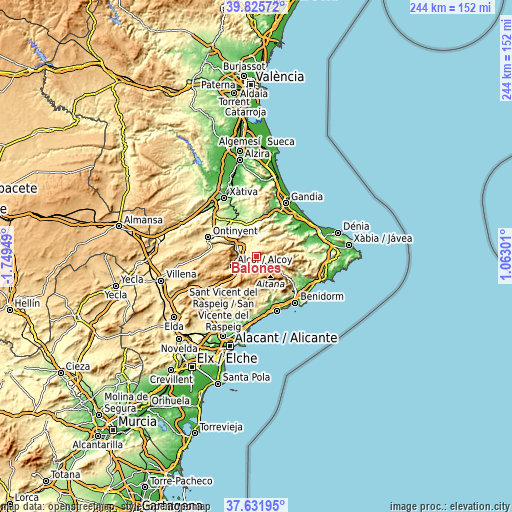
| \ | Map #1 | Topo.Map |
| Scale [m] | 392..1340 m | × |
| Scale [ft] | 1286..4396 ft | × |
| Average | 676.9 m = 2221 ft | × |
| Width | 7.62 km = 4.7 mi | 243.9 km = 151.6 mi |
| Height | 7.62 km = 4.7 mi | 243.9 km = 151.6 mi |
| ↑Max Latitude | 38.77153° | 39.82572° |
| Latitude at center | 38.73726° | 38.73726° |
| ↓Min Latitude | 38.702973° | 37.63195° |
| ← Min Longitude | -0.387185° | -1.74949° |
| Longitude center | -0.34324° | -0.34324° |
| →Max Longitude | -0.299295° | 1.06301° |
Nearby cities:
Cities around Balones sort by population:
• Benilloba elevation 541 m
5.8 km,  224°
224°
• Planes 443 m
5.3 km,  0°
0°
• Benimarfull 420 m
6 km,  316°
316°
• Gorga 555 m
2.3 km,  208°
208°
• Benasau 707 m
5.2 km,  179°
179°
• Alcocer de Planes 354 m
8.2 km, 321°
• Millena 645 m
1.8 km,  247°
247°
• Benimassot 748 m
5.4 km,  74°
74°
• Almudaina 581 m
2.6 km,  344°
344°
• Facheca 782 m
6.6 km,  92°
92°
• Benillup 553 m
3.7 km,  300°
300°
• Tollos 769 m
6.3 km, 70°
Multilingual:
 En español:
Balones elevación 693 m.
 En France:
Balones élévation 693 m.


Sources and notes:
- [note 1] Map square and city borders are not equal. Map elevation data is calculated only from area inside that square.
- [src 1] Elevation data from geonames database provided with same terms of usage.
- [src 2] The elevation map of Balones is generated using elevation data from NASA's 3 arcsec (90m) resolution SRTM data.
- [src 3] Base (background) map © OpenStreetMap contributors tiles are generated by Geofabrik and OpenTopoMap.
Copyright & License:
This Balones Elevation Map is licensed under CC BY-SA. You may reuse any part from this page, if you give a proper credit by linking to this URL:
 More info on terms of use page.