Barx elevation
Barx (Valencia, Província de València), Spain elevation is 421 meters and Barx elevation in feet is 1381 ft above sea level [src 1]. Barx is a seat of a third-order administrative division (feature code) with elevation that is 182 meters (597 ft) smaller than average city elevation in Spain.
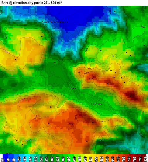
Below is the Elevation map of Barx, which displays elevation range with different colors. Scale of the first map is from 27 to 829 m (89 to 2720 ft) with average elevation of 408.1 meters (=1339 ft) [note 1]
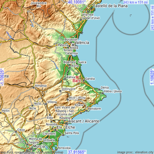
These maps also provides idea of topography and contour of this city, they are displayed at different zoom levels. More info about maps, scale and edge coordinates you can find below images.
| \ | Map #1 | Topo.Map |
| Scale [m] | 27..829 m | × |
| Scale [ft] | 89..2720 ft | × |
| Average | 408.1 m = 1339 ft | × |
| Width | 7.59 km = 4.7 mi | 243 km = 151 mi |
| Height | 7.59 km = 4.7 mi | 243 km = 151 mi |
| ↑Max Latitude | 39.050806° | 40.10081° |
| Latitude at center | 39.01667° | 39.01667° |
| ↓Min Latitude | 38.982518° | 37.91565° |
| ← Min Longitude | -0.343945° | -1.70625° |
| Longitude center | -0.3° | -0.3° |
| →Max Longitude | -0.256055° | 1.10625° |
Nearby cities:
Cities around Barx sort by population:
• Tavernes de la Valldigna elevation 20 m
6.8 km,  25°
25°
• Xeraco,Jaraco 14 m
7.4 km,  75°
75°
• Simat de la Valldigna 449 m
2.3 km,  322°
322°
• Llutxent 250 m
10.2 km,  205°
205°
• Xeresa 9 m
7.2 km,  90°
90°
• Favara 39 m
11.2 km,  7°
7°
• Barxeta 145 m
10.1 km,  270°
270°
• Rótova 108 m
10.1 km,  158°
158°
• Llocnou de Sant Jeroni 136 m
11.2 km,  172°
172°
• Alfauir 80 m
10.2 km,  154°
154°
• Almiserà 136 m
11.2 km, 172°
• Pinet 343 m
5.1 km,  220°
220°
Multilingual:
 En español:
Bárig elevación 421 m.
 En France:
Barx élévation 421 m.


Sources and notes:
- [note 1] Map square and city borders are not equal. Map elevation data is calculated only from area inside that square.
- [src 1] Elevation data from geonames database provided with same terms of usage.
- [src 2] The elevation map of Barx is generated using elevation data from NASA's 3 arcsec (90m) resolution SRTM data.
- [src 3] Base (background) map © OpenStreetMap contributors tiles are generated by Geofabrik and OpenTopoMap.
Copyright & License:
This Barx Elevation Map is licensed under CC BY-SA. You may reuse any part from this page, if you give a proper credit by linking to this URL:
 More info on terms of use page.