Belmonte elevation
Belmonte (Castille-La Mancha, Provincia de Cuenca), Spain elevation is 749 meters and Belmonte elevation in feet is 2457 ft above sea level [src 1]. Belmonte is a seat of a third-order administrative division (feature code) with elevation that is 146 meters (479 ft) bigger than average city elevation in Spain.
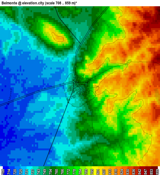
Below is the Elevation map of Belmonte, which displays elevation range with different colors. Scale of the first map is from 708 to 859 m (2323 to 2818 ft) with average elevation of 764 meters (=2507 ft) [note 1]
These maps also provides idea of topography and contour of this city, they are displayed at different zoom levels. More info about maps, scale and edge coordinates you can find below images.
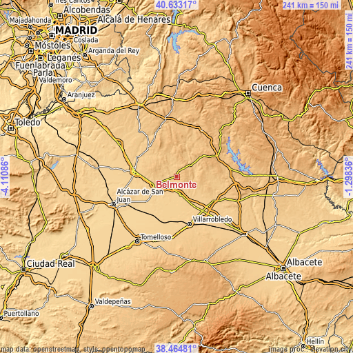
| \ | Map #1 | Topo.Map |
| Scale [m] | 708..859 m | × |
| Scale [ft] | 2323..2818 ft | × |
| Average | 764 m = 2507 ft | × |
| Width | 7.53 km = 4.7 mi | 241.1 km = 149.8 mi |
| Height | 7.53 km = 4.7 mi | 241.1 km = 149.8 mi |
| ↑Max Latitude | 39.591333° | 40.63317° |
| Latitude at center | 39.55746° | 39.55746° |
| ↓Min Latitude | 39.52357° | 38.46481° |
| ← Min Longitude | -2.748555° | -4.11086° |
| Longitude center | -2.70461° | -2.70461° |
| →Max Longitude | -2.660665° | -1.29836° |
Nearby cities:
Cities around Belmonte sort by population:
• Las Pedroñeras elevation 706 m
12.2 km,  167°
167°
• Mota del Cuervo 710 m
15.5 km,  246°
246°
• La Alberca de Záncara 800 m
18.8 km,  104°
104°
• El Pedernoso 712 m
8.7 km,  204°
204°
• Los Hinojosos 772 m
11.6 km,  296°
296°
• Osa de la Vega 763 m
12.3 km,  337°
337°
• Tresjuncos 814 m
16.5 km, 344°
• Fuentelespino de Haro 850 m
15 km,  11°
11°
• Villar de la Encina 841 m
18 km,  60°
60°
• Carrascosa de Haro 786 m
14.6 km,  72°
72°
• Monreal del Llano 735 m
5 km,  284°
284°
• Rada de Haro 825 m
7.3 km,  78°
78°
Multilingual:
 En español:
Belmonte elevación 749 m.
 En France:
Belmonte élévation 749 m.
 Auf Deutsch:
Belmonte höhe über dem Meeresspiegel ist 749 m.

Sources and notes:
- [note 1] Map square and city borders are not equal. Map elevation data is calculated only from area inside that square.
- [src 1] Elevation data from geonames database provided with same terms of usage.
- [src 2] The elevation map of Belmonte is generated using elevation data from NASA's 3 arcsec (90m) resolution SRTM data.
- [src 3] Base (background) map © OpenStreetMap contributors tiles are generated by Geofabrik and OpenTopoMap.
Copyright & License:
This Belmonte Elevation Map is licensed under CC BY-SA. You may reuse any part from this page, if you give a proper credit by linking to this URL:
 More info on terms of use page.