Benaguasil elevation
Benaguasil (Valencia, Província de València), Spain elevation is 103 meters and Benaguasil elevation in feet is 338 ft above sea level [src 1]. Benaguasil is a seat of a third-order administrative division (feature code) with elevation that is 500 meters (1640 ft) smaller than average city elevation in Spain.
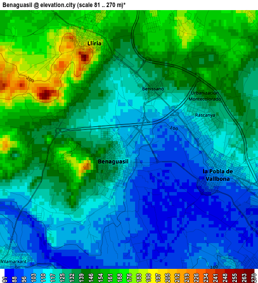
Below is the Elevation map of Benaguasil, which displays elevation range with different colors. Scale of the first map is from 81 to 270 m (266 to 886 ft) with average elevation of 129.5 meters (=425 ft) [note 1]
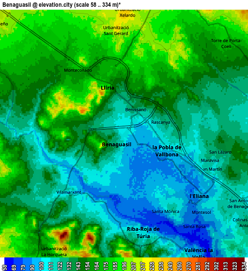
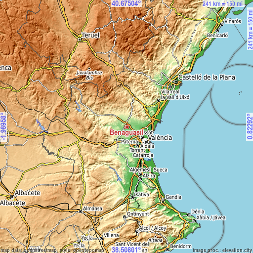
These maps also provides idea of topography and contour of this city, they are displayed at different zoom levels. More info about maps, scale and edge coordinates you can find below images.
| \ | Map #1 | Map #2 | Topo.Map |
| Scale [m] | 81..270 m | 58..334 m | × |
| Scale [ft] | 266..886 ft | 190..1096 ft | × |
| Average | 129.5 m = 425 ft | 143.9 m = 472 ft | × |
| Width | 7.53 km = 4.7 mi | 15.06 km = 9.4 mi | 241 km = 149.8 mi |
| Height | 7.53 km = 4.7 mi | 15.06 km = 9.4 mi | 240.9 km = 149.7 mi |
| ↑Max Latitude | 39.633852° | 39.667688° | 40.67504° |
| Latitude at center | 39.6° | 39.6° | 39.6° |
| ↓Min Latitude | 39.566131° | 39.532246° | 38.50801° |
| ← Min Longitude | -0.627275° | -0.671221° | -1.98958° |
| Longitude center | -0.58333° | -0.58333° | -0.58333° |
| →Max Longitude | -0.539385° | -0.495439° | 0.82292° |
Nearby cities:
Cities around Benaguasil sort by population:
• Llíria elevation 174 m
3.4 km,  338°
338°
• Bétera 110 m
10.5 km,  95°
95°
• Ribarroja del Turia 103 m
6.1 km,  169°
169°
• La Pobla de Vallbona 112 m
2.5 km, 96°
• L'Eliana 91 m
5.7 km,  130°
130°
• Vilamarxant 114 m
4.9 km,  225°
225°
• Náquera 220 m
15.3 km,  68°
68°
• Pedralba 149 m
11.4 km,  270°
270°
• Casinos 300 m
14.9 km,  318°
318°
• Benisanó 148 m
2.3 km,  37°
37°
• Olocau 267 m
11.9 km,  21°
21°
• Domeño 210 m
10.1 km,  312°
312°
Multilingual:
 En español:
Benaguacil elevación 103 m.
 En France:
Benaguasil élévation 103 m.
 Auf Deutsch:
Benaguasil höhe über dem Meeresspiegel ist 103 m.

Sources and notes:
- [note 1] Map square and city borders are not equal. Map elevation data is calculated only from area inside that square.
- [src 1] Elevation data from geonames database provided with same terms of usage.
- [src 2] The elevation map of Benaguasil is generated using elevation data from NASA's 3 arcsec (90m) resolution SRTM data.
- [src 3] Base (background) map © OpenStreetMap contributors tiles are generated by Geofabrik and OpenTopoMap.
Copyright & License:
This Benaguasil Elevation Map is licensed under CC BY-SA. You may reuse any part from this page, if you give a proper credit by linking to this URL:
 More info on terms of use page.