Benamejí elevation
Benamejí (Andalusia, Province of Córdoba), Spain elevation is 462 meters and Benamejí elevation in feet is 1516 ft above sea level [src 1]. Benamejí is a seat of a third-order administrative division (feature code) with elevation that is 141 meters (463 ft) smaller than average city elevation in Spain.
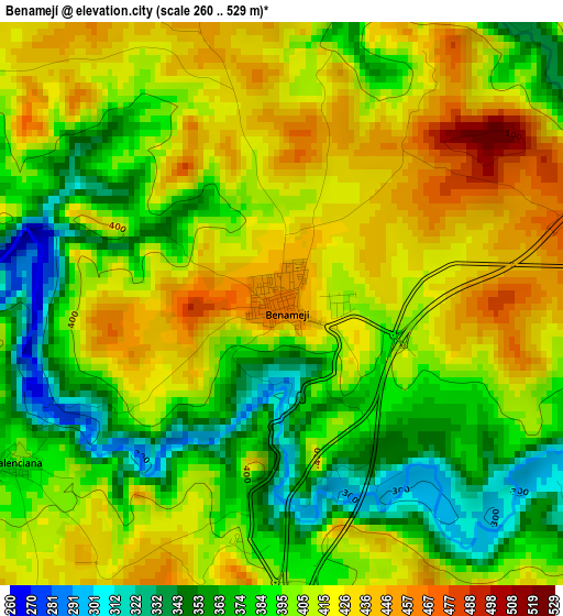
Below is the Elevation map of Benamejí, which displays elevation range with different colors. Scale of the first map is from 260 to 529 m (853 to 1736 ft) with average elevation of 401.1 meters (=1316 ft) [note 1]
These maps also provides idea of topography and contour of this city, they are displayed at different zoom levels. More info about maps, scale and edge coordinates you can find below images.
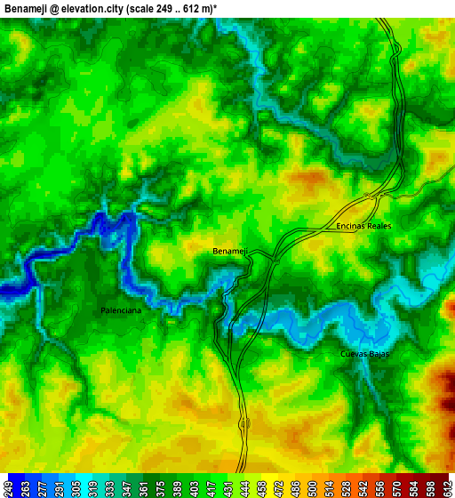
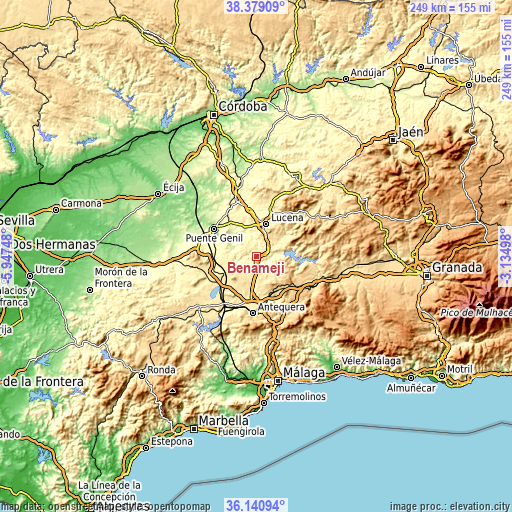
| \ | Map #1 | Map #2 | Topo.Map |
| Scale [m] | 260..529 m | 249..612 m | × |
| Scale [ft] | 853..1736 ft | 817..2008 ft | × |
| Average | 401.1 m = 1316 ft | 410.6 m = 1347 ft | × |
| Width | 7.78 km = 4.8 mi | 15.55 km = 9.7 mi | 248.9 km = 154.7 mi |
| Height | 7.78 km = 4.8 mi | 15.55 km = 9.7 mi | 248.9 km = 154.7 mi |
| ↑Max Latitude | 37.303294° | 37.338242° | 38.37909° |
| Latitude at center | 37.26833° | 37.26833° | 37.26833° |
| ↓Min Latitude | 37.23335° | 37.198353° | 36.14094° |
| ← Min Longitude | -4.585175° | -4.629121° | -5.94748° |
| Longitude center | -4.54123° | -4.54123° | -4.54123° |
| →Max Longitude | -4.497285° | -4.453339° | -3.13498° |
Nearby cities:
Cities around Benamejí sort by population:
• Lucena elevation 493 m
16.4 km,  17°
17°
• Rute 658 m
16.6 km,  66°
66°
• Casariche 305 m
19.5 km,  278°
278°
• Alameda 430 m
12.3 km,  237°
237°
• Villanueva de Algaidas 551 m
12.4 km,  139°
139°
• Mollina 475 m
18.9 km,  212°
212°
• Cuevas de San Marcos 435 m
11.2 km,  90°
90°
• Badolatosa 225 m
12.5 km,  290°
290°
• Encinas Reales 444 m
4.7 km,  82°
82°
• Palenciana 395 m
4.3 km, 238°
• Cuevas Bajas 329 m
6 km,  127°
127°
• Moriles 381 m
19.6 km,  342°
342°
Multilingual:
 En español:
Benamejí elevación 462 m.
 En France:
Benamejí élévation 462 m.
 Auf Deutsch:
Benamejí höhe über dem Meeresspiegel ist 462 m.

Sources and notes:
- [note 1] Map square and city borders are not equal. Map elevation data is calculated only from area inside that square.
- [src 1] Elevation data from geonames database provided with same terms of usage.
- [src 2] The elevation map of Benamejí is generated using elevation data from NASA's 3 arcsec (90m) resolution SRTM data.
- [src 3] Base (background) map © OpenStreetMap contributors tiles are generated by Geofabrik and OpenTopoMap.
Copyright & License:
This Benamejí Elevation Map is licensed under CC BY-SA. You may reuse any part from this page, if you give a proper credit by linking to this URL:
 More info on terms of use page.