Benicolet elevation
Benicolet (Valencia, Província de València), Spain elevation is 238 meters and Benicolet elevation in feet is 781 ft above sea level [src 1]. Benicolet is a seat of a third-order administrative division (feature code) with elevation that is 365 meters (1198 ft) smaller than average city elevation in Spain.
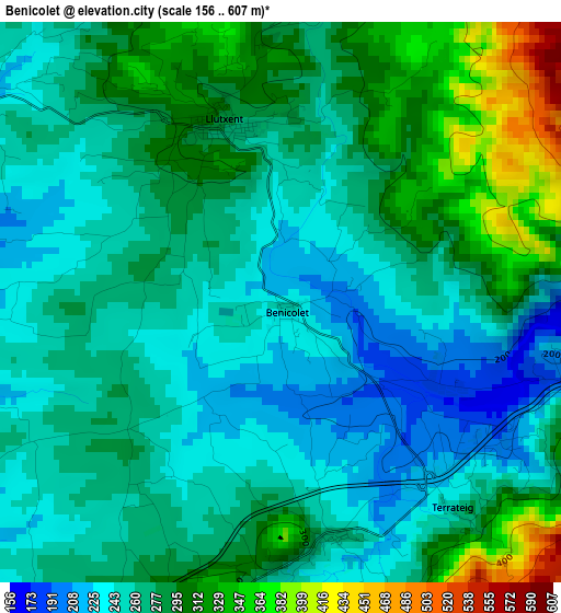
Below is the Elevation map of Benicolet, which displays elevation range with different colors. Scale of the first map is from 156 to 607 m (512 to 1991 ft) with average elevation of 274.3 meters (=900 ft) [note 1]
These maps also provides idea of topography and contour of this city, they are displayed at different zoom levels. More info about maps, scale and edge coordinates you can find below images.
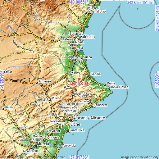
| \ | Map #1 | Topo.Map |
| Scale [m] | 156..607 m | × |
| Scale [ft] | 512..1991 ft | × |
| Average | 274.3 m = 900 ft | × |
| Width | 7.6 km = 4.7 mi | 243.3 km = 151.2 mi |
| Height | 7.6 km = 4.7 mi | 243.3 km = 151.2 mi |
| ↑Max Latitude | 38.954052° | 40.00551° |
| Latitude at center | 38.91987° | 38.91987° |
| ↓Min Latitude | 38.885671° | 37.81736° |
| ← Min Longitude | -0.390885° | -1.75319° |
| Longitude center | -0.34694° | -0.34694° |
| →Max Longitude | -0.302995° | 1.05931° |
Nearby cities:
Cities around Benicolet sort by population:
• Quatretonda elevation 226 m
5.7 km,  306°
306°
• Llutxent 250 m
1.5 km,  349°
349°
• Castelló de Rugat 327 m
4.4 km,  202°
202°
• Rótova 108 m
7.8 km,  80°
80°
• Montichelvo 272 m
3.2 km,  171°
171°
• Llocnou de Sant Jeroni 136 m
5.5 km,  93°
93°
• Terrateig 264 m
3.7 km,  140°
140°
• Ráfol de Salem 293 m
7.5 km,  217°
217°
• Almiserà 136 m
5.5 km, 93°
• Rugat 292 m
4.7 km, 195°
• Pinet 343 m
6.9 km,  5°
5°
• Castellonet de la Conquesta 196 m
7 km, 92°
Multilingual:
 En español:
Benicolet elevación 238 m.
 En France:
Benicolet élévation 238 m.
 Auf Deutsch:
Benicolet höhe über dem Meeresspiegel ist 238 m.

Sources and notes:
- [note 1] Map square and city borders are not equal. Map elevation data is calculated only from area inside that square.
- [src 1] Elevation data from geonames database provided with same terms of usage.
- [src 2] The elevation map of Benicolet is generated using elevation data from NASA's 3 arcsec (90m) resolution SRTM data.
- [src 3] Base (background) map © OpenStreetMap contributors tiles are generated by Geofabrik and OpenTopoMap.
Copyright & License:
This Benicolet Elevation Map is licensed under CC BY-SA. You may reuse any part from this page, if you give a proper credit by linking to this URL:
 More info on terms of use page.