Benimuslem elevation
Benimuslem (Valencia, Província de València), Spain elevation is 25 meters and Benimuslem elevation in feet is 82 ft above sea level [src 1]. Benimuslem is a seat of a third-order administrative division (feature code) with elevation that is 578 meters (1896 ft) smaller than average city elevation in Spain.
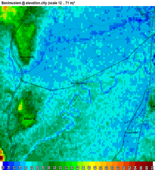
Below is the Elevation map of Benimuslem, which displays elevation range with different colors. Scale of the first map is from 12 to 71 m (39 to 233 ft) with average elevation of 23.6 meters (=77 ft) [note 1]
These maps also provides idea of topography and contour of this city, they are displayed at different zoom levels. More info about maps, scale and edge coordinates you can find below images.
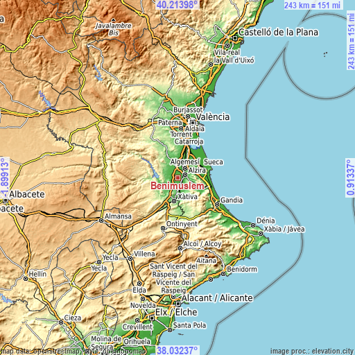
| \ | Map #1 | Topo.Map |
| Scale [m] | 12..71 m | × |
| Scale [ft] | 39..233 ft | × |
| Average | 23.6 m = 77 ft | × |
| Width | 7.58 km = 4.7 mi | 242.6 km = 150.7 mi |
| Height | 7.58 km = 4.7 mi | 242.6 km = 150.7 mi |
| ↑Max Latitude | 39.1657° | 40.21398° |
| Latitude at center | 39.13162° | 39.13162° |
| ↓Min Latitude | 39.097523° | 38.03237° |
| ← Min Longitude | -0.536825° | -1.89913° |
| Longitude center | -0.49288° | -0.49288° |
| →Max Longitude | -0.448935° | 0.91337° |
Nearby cities:
Cities around Benimuslem sort by population:
• Alzira elevation 26 m
5.5 km,  68°
68°
• Algemesí 32 m
8.2 km,  37°
37°
• Carcaixent 25 m
4 km,  105°
105°
• L'Alcúdia 43 m
7.4 km,  351°
351°
• Alberic 29 m
2.6 km,  230°
230°
• Villanueva de Castellón 41 m
6.2 km,  195°
195°
• Guadassuar 34 m
6.2 km,  11°
11°
• La Pobla Llarga 33 m
5.8 km,  157°
157°
• Masalavés 36 m
2.9 km,  297°
297°
• Gavarda 30 m
7.3 km,  222°
222°
• Senyera 43 m
7.2 km,  184°
184°
• San Juan de Énova 40 m
6.8 km, 175°
Multilingual:
 En español:
Benimuslem elevación 25 m.
 En France:
Benimuslem élévation 25 m.
 Auf Deutsch:
Benimuslem höhe über dem Meeresspiegel ist 25 m.

Sources and notes:
- [note 1] Map square and city borders are not equal. Map elevation data is calculated only from area inside that square.
- [src 1] Elevation data from geonames database provided with same terms of usage.
- [src 2] The elevation map of Benimuslem is generated using elevation data from NASA's 3 arcsec (90m) resolution SRTM data.
- [src 3] Base (background) map © OpenStreetMap contributors tiles are generated by Geofabrik and OpenTopoMap.
Copyright & License:
This Benimuslem Elevation Map is licensed under CC BY-SA. You may reuse any part from this page, if you give a proper credit by linking to this URL:
 More info on terms of use page.