Bormujos elevation
Bormujos (Andalusia, Provincia de Sevilla), Spain elevation is 113 meters and Bormujos elevation in feet is 371 ft above sea level [src 1]. Bormujos is a seat of a third-order administrative division (feature code) with elevation that is 490 meters (1608 ft) smaller than average city elevation in Spain.
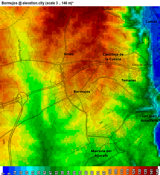
Below is the Elevation map of Bormujos, which displays elevation range with different colors. Scale of the first map is from 3 to 146 m (10 to 479 ft) with average elevation of 85.7 meters (=281 ft) [note 1]
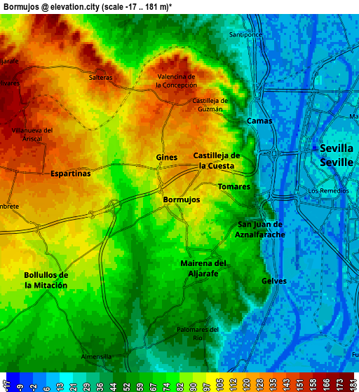
These maps also provides idea of topography and contour of this city, they are displayed at different zoom levels. More info about maps, scale and edge coordinates you can find below images.
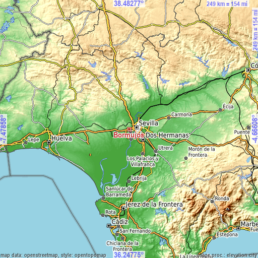
| \ | Map #1 | Map #2 | Topo.Map |
| Scale [m] | 3..146 m | -17..181 m | × |
| Scale [ft] | 10..479 ft | -56..594 ft | × |
| Average | 85.7 m = 281 ft | 66 m = 217 ft | × |
| Width | 7.77 km = 4.8 mi | 15.53 km = 9.6 mi | 248.5 km = 154.4 mi |
| Height | 7.77 km = 4.8 mi | 15.53 km = 9.6 mi | 248.5 km = 154.4 mi |
| ↑Max Latitude | 37.408495° | 37.443394° | 38.48277° |
| Latitude at center | 37.37358° | 37.37358° | 37.37358° |
| ↓Min Latitude | 37.338649° | 37.303701° | 36.24775° |
| ← Min Longitude | -6.116275° | -6.160221° | -7.47858° |
| Longitude center | -6.07233° | -6.07233° | -6.07233° |
| →Max Longitude | -6.028385° | -5.984439° | -4.66608° |
Nearby cities:
Cities around Bormujos sort by population:
• Mairena del Aljarafe elevation 70 m
3.3 km,  166°
166°
• Camas 11 m
4.7 km,  47°
47°
• Tomares 76 m
2.3 km,  92°
92°
• San Juan de Aznalfarache 55 m
3.5 km,  119°
119°
• Castilleja de la Cuesta 101 m
2.2 km, 51°
• Gines 119 m
1.5 km,  342°
342°
• Espartinas 132 m
4.8 km,  280°
280°
• Gelves 8 m
5.9 km,  136°
136°
• Valencina de la Concepción 151 m
4.7 km,  357°
357°
• Palomares del Río 39 m
5.8 km, 168°
• Salteras 156 m
6.2 km,  327°
327°
• Castilleja de Guzmán 135 m
4.3 km,  20°
20°
Multilingual:
 En español:
Bormujos elevación 113 m.
 En France:
Bormujos élévation 113 m.
 Auf Deutsch:
Bormujos höhe über dem Meeresspiegel ist 113 m.

Sources and notes:
- [note 1] Map square and city borders are not equal. Map elevation data is calculated only from area inside that square.
- [src 1] Elevation data from geonames database provided with same terms of usage.
- [src 2] The elevation map of Bormujos is generated using elevation data from NASA's 3 arcsec (90m) resolution SRTM data.
- [src 3] Base (background) map © OpenStreetMap contributors tiles are generated by Geofabrik and OpenTopoMap.
Copyright & License:
This Bormujos Elevation Map is licensed under CC BY-SA. You may reuse any part from this page, if you give a proper credit by linking to this URL:
 More info on terms of use page.